Route Description
The Offa's Dyke Path National Trail was opened in the summer of 1971, linking Sedbury Cliffs near Chepstow on the banks of the Severn estuary with the North Wales coastal town of Prestatyn. The Trail is named after, and often follows, the spectacular Offa's Dyke, a great frontier earthwork, which Offa the King of Mercia from 757 to 796 A.D. ordered to be constructed. This holiday covers the 97 mile Northern section of Offa's Dyke Path from Knighton to Prestatyn. The following is intended to provide further information about the route. Please note that all distances and heights are approximate and along with all the other information are provided as an aid to describe the route.
Terrain
The terrain varies from riverside paths, country lanes, farmland, rolling hills and mountain paths.
Waymarking and Navigation
The route is sensibly waymarked and generally easy to follow with the aid of a map and guidebook.
Knighton (175m) to Brompton (140m).
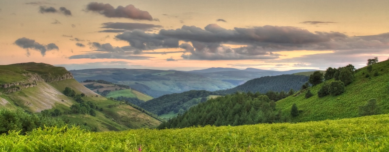
The section from Knighton to Brompton is generally regarded to be the toughest. This is the ‘switchback’ section and the ODP rises and falls through the Shropshire Hills an Area of Outstanding Natural Beauty. However the views make the effort worthwhile. Shortly after leaving Knighton the ODP climbs into the Shropshire Hills, the highest point is 430metres as the ODP crosses Llanfair Hill alongside some of the best preserved sections of Offa’s Dyke. Just above Newcastle on Clun you are at the true midpoint of the the full route ODP, with its midway marker. The ODP descends into the Clun Valley. The ODP climbs into the hills again and at Hergan there is what seems to be a natural break in the Dyke, where the Shropshire Way joins the Dyke for a short distance. There are very few villages on this section but a number of hidden gems await the walker, one of these is Churchtown - at the foot of a narrow valley you find the church, but no sign of a town. Within a couple of miles the ODP crosses the Kerry Ridgeway trail from this point on it is level or downhill. Shortly before Brompton the ODP goes through the hamlet of Cwm and passes Mellington Hall, areas with a scattering of accommodation.
Brompton (140m) to Buttington Bridge (70m).
For the next couple of miles the ODP follows the Dyke across fairly level terrain as it passes to the right of Montgomery. The ODP then rises to pass Nantcribba and over the next few miles continues to rise to Beacon Ring (408m), the earthworks of the ancient hill fort on the summit of Long Mountain, with views down to Welshpool. The ODP then descends to Buttington Bridge where you meet the River Severn, from where it is a short walk into the busy market town of Welshpool.
Buttington Bridge (70m) to Trefonen (175m).
This walk to Llanymynech is almost flat throughout and is the easiest section of the ODP. Leaving Buttington Bridge the ODP follows the Montgomery Canal and then River Severn for several miles before crossing fields to the village of Four Crosses. The ODP then follows the Montgomery Canal to the town of Llanymynech (75m) where the Wales – England border is the main street! After the flattest section the ODP, it returns to rising and falling via Llanymynech Hill (226m) and Moelydd (285m). The summit of Moelydd is one of the surprises of the day - the 360 degree views are stunning and a topascope helps you identify the many hills you see. Trefonen is just a short walk away.
Trefonen (175m) to Llangollen (100m).
Continuing its way north across the rolling countryside the ODP passes a few miles from the town of Oswestry. Oswestry, or "Oswald's Tree", is generally thought to be derived from Oswald's death there and the legends surrounding it. Oswald lived in the 7th century and was the powerful King of Northumbria. He spread Christian religion in Northumbria and soon after his death came to be regarded as a saint. The 97 mile route from Holy Island to Heavenfield, in Northumbria, is named after St Oswald. The ODP continues across the rolling countryside then descends to the River Ceiriog at Castle Mill, close to Chirk. From the river the summer season path leads past Chirk Castle, set in 480 acres of parklands. With over 700 years of history, and as the last castle from this period still lived in today, you can visit if time allows. From the castle the ODP crosses a few miles of farmland towards Trevor where you have the option to cross Pontcysyllte Aqueduct, now listed as a World Heritage Site it is the largest aqueduct in Britain. It is now only a few miles to Llangollen, a town situated on the River Dee, and there are two possible routes to take.
Llangollen (100m) to Clwyd Gate (286m).
The ODP is above Llangollen where it passes medieval castle Dinas Bran (320m), overlooking the town, at Trevor Rocks. A climb up from the town brings you to the route. This area is now part of the Clwydian Range, the series of hills and mountains before the ODP arrives at Prestatyn. For the next few miles the ODP contours round below the crags of Eglwyseg Mountain to the well named ‘World’s End’ (300m). The ODP then passes over the moorland (475m) before descending through Llandegla Forest, to Llandegla (250m). For a short distance the route stays close to the River Alyn then climbs bank into Clwydian Range and for much of the time you are following the heather clad ridge that is so prominent in this area to Clwyd Gate.
Clwyd Gate (286m) to Bodfari (40m).
From Clwyd Gate the ODP continues along the ridge over the hills and mountains of the Clwydian Range. It passes over or beside a string of ancient hill forts on its journey including Foel Fenlli, Moel Arthur and Penycloddiau. The key landmark on this section of the ODP is Jubilee Tower on the top of Moel Famau (554m). The tower was built to celebrate the 50th year of the reign of George 3rd in 1810. The summit of Moel Famau is also the high point on this section of the ODP. This section affords magnificent views westwards across the Vale of Clwyd to Snowdonia and eastwards to the English border and beyond. The ODP descends from the hills into the valley and the village of Bodfari.
Bodfari (40m) to Prestatyn (5m).
For the next few miles the ODP continues over the last remaining, but lower, hills of the Clwydian Range to Rhuallt village. The ODP continues over the rolling countryside and views of the sea open up as you approach journeys end. Fabulous views of Snowdonia and the North Wales coast are seen from Prestatyn Hillside before you descend into the town and onwards to the end of the ODP at Prestatyn beach. Traditionally at this point boots and socks are removed and a walk into the Irish Sea marks the end of your journey and gives some relief to those tired feet.
More Information?
For more information or to make an enquiry, please don't hesitate to call or email us.
