Route Description
Hadrians Wall Path is an 84 mile linear route that follows the worlds finest surviving Roman frontier from Bowness-on-Solway, near Carlisle to Wallsend, near Newcastle. The path runs almost coast to coast across the narrow isthmus at the top of England. The idea to create the Wall, and prevent the attacks and movements of the Celtic Barbarians from the North (Scotland), was that of Roman Emperor Hadrian Aelius. In AD122 work commenced on the near ten year task to build the Wall and its forts, milecastles and turrets. Fifteen thousand men from 3 Roman Legions were employed in the task. The following is intended to provide further information about the route. Please note that all distances and heights in this document are approximate and along with all the other information are provided as an aid to describe the route.
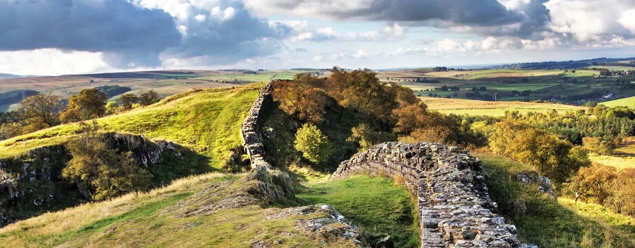
Terrain
Generally the path follows a grassland route with paved and tarmac sections, but rocky paths will be encountered in the Pennine mid section of the route.
Waymarking and Navigation
The route is sensibly waymarked and generally easy to follow with the aid of a map and guidebook.
Bowness-on-Solway (height above sea level 5m) to Carlisle (15m).
In the village of Bowness-on-Solway a small shelter and pretty garden mark the start of the walk alongside this historic ancient frontier. Not since the end of the Roman occupation of Britain, some 1600 years ago, has it been possible to walk along the entire length of Hadrian's Wall. The first section of the route is easy going as the path follows a road alongside the peaceful Solway Estuary. There are wonderful views across the estuary to the hills in Southern Scotland. You pass through the village of Burgh by Sands (20m) and continue on an almost level path. You meet the River Eden and follow it to the border city of Carlisle, close to the Scottish border.. The Romans established a settlement here to serve the forts on Hadrian’s Wall. Carlisle Castle is a great medieval fortress which houses the Border Regiment Museum. Carlisle is also at the end of the 70 mile Cumbria Way long distance walking route which crosses the Lake District from Ulverston at the southern end.
Carlisle (15m) to Gilsland (130m).
Hadrian’s Wall path now continues close to the River Eden to Crosby-on-Eden (30m). Continuing over farmland there are the occasional humps and bumps in the ground and a glimpse of vallum ditch showing the line of the Wall. The route is gradually climbing as you walk across farmland to the village of Newtown (70m) and shortly after Walton (80m). In a few miles you pass the first section of Wall at Hare Hill near the hamlet of Banks (120m). Continue across farmland to to Birdoswald Fort (open daily from April to September), which is a mile before Gilsland.
Gilsland (130m) to Steel Rigg (280m).
From Gilsland continue across farmland for a few miles then the landscape changes and the path begins to cross the rough and rugged landscape of the Pennine Hills. Crossing the Pennine Hills there are the most complete sections of the Wall, forts, milecastles, and turret sections. There isn't very much between yourself and the Shetlands, a wasteland occupied by ‘The Barbarians’, or so the Romans called them, two millennia ago. The Wall was built on a line of rocky Crags which created a high defence to potential invaders from the north. There are excellent views of the surrounding area, Scotland and Northumberland National park. For the several miles the path rises and falls as it crosses the Crags. The path reaches its highest point at Windshields Crags (345m). In a short distance you meet the road to Steel Rigg. Approximately 2 miles from this point is Vindolanda Fort, both Vindolanda and Housesteads are open daily from April to September.
Steel Rigg (280m) to Chollerford (100m).
The path continues to rise and fall as it follows the Wall across the Crags, passing Housesteads Fort (275m). There are excellent views of the surrounding area and Northumberland National park. After crossing Sewingshields Crags (300m) the route descends to milecastle 34 (250m) where it meets the B6318, which is dubbed the military road, not on account of the Romans, rather General Wade, builder of military supply roads in the 18th century in response to the Jacobite rebellion. The path continues to follow the line of the military road for several miles and gradually descends. It passes Limestone Corner, the most northerly point of the Wall. Shortly before Chollerford the path passes the ruins of Chesters Roman Fort and Chesters Museum, open daily from April to September.
Chollerford (100m) to Heddon-on-the-Wall (120m)/Wylam (10m).
From Chollerford the path crosses the bridge over River North Tyne. The path continues to follow the line of the military road. The path passes St. Oswald’s Church at Heavenfield (220m), the site of a 7th century battle between Northumbrian forces and an invading Welsh army. The battle was a decisive victory for Oswald, King of Northumbria. At the junction with the A68 road is Portgate (200m), which was the junction with the Wall and Dere Street, the main Roman road into Scotland. The historical market town of Corbridge is a few miles to the south of the path. The route is almost straight and passes the hamlets of Halton Red House and Wallhouse. The path is mainly level as it leads through countryside and continues its way over mainly level terrain alongside the line of the old military road, where the Wall once stood, to Heddon-on-the-Wall.
Heddon-on-the-Wall (120m)/Wylam (10m) to Wallsend (5m).
At Heddon-on-the-Wall is the last section of the Wall and evidence of Roman construction. The path descends to the River Tyne and the Wylam Waggonway, to the right is Wylam birthplace of George Stephenson. You continue to follow the River and in a few miles the route passes Newburn (5m). The route leads to Newcastle Quayside, a vibrant area with restaurants and cafes. The bridges, including the tilting Millennium Bridge ('Winking Eye Bridge') link Newcastle to Gateshead. Continuing along the River the route passes the shipyards and Newcastle’s industrial centre for the last several miles. The path ends at the remains of Segedunum Roman Fort, Wallsend.
More Information?
For more information or to make an enquiry, please don't hesitate to call or email us.
