Route Description
The Coast to Coast Part 1 (west) is an 83 mile route across Cumbria. The route is the western half of Alfred Wainwright's famous coast to coast route. The following is intended to provide further information about the route. Please note that all distances and heights in this document are approximate and along with all the other information are provided as an aid to describe the route.
Terrain
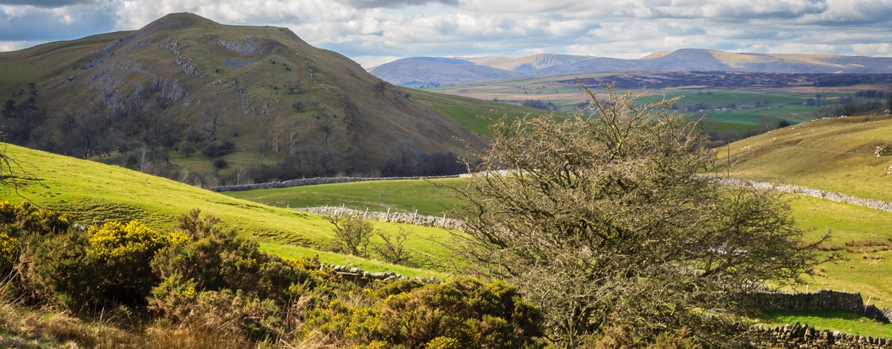
The route is mainly through the Lake District Mountains with some steep ascents and descents. There are also sections of undulating countryside. The terrain on this trail is a diversity of rocky mountain paths,limestone plateau’s, country lanes, rolling hillsides and farmland.
Waymarking and Navigation
Due to its popularity the route has recently become a National Trail. Waymarking is limited and navigation skills are required with a GPS, guidebook, map and compass. Waypoints for the route can be downloaded onto your GPS.
St Bees
The seaside village of St Bees on the Cumbria (west) coast is the official starting point for Wainwright's world famous Coast to Coast walk.
St Bees to Cleator (village height above sea level 60M). Distance 9 miles
A plaque on the seafront marks the start of Wainwrights coast to coast walk. Tradition says to dip your toe in the sea and then collect a small pebble to carry with you to the east coast. The route heads north across the coastal path with views of Scotland and the Isle of Man. Leave the coastal path and head east towards the Lake District Mountains. The route passes through the villages of Sandwith and Moor Row to Cleator.
Cleator to Ennerdale Bridge (100M). Distance 5 miles
From Cleator the route starts to climb and a steep walk takes you to Dent (352M). Admire the views before continuing across the hilltop. Descend steeply down a forest track, follow Nannycatch Beck and then the roadside paths to Ennerdale Bridge.
Ennerdale Bridge (100M) to Rosthwaite (100M). Distance 14 miles
Follow the country lanes to Ennerdale Water then the rocky path along the banks of the Lake. At the far end of the Lake make for the forest track that climbs gradually along Ennerdale valley to the remote Black Sail Hut YHA (290M). The adventurous and experienced fell walkers can leave the track and climb to follow the alternative route over High Stile (807M), rejoining the main route near the top of Loft Beck. From the YHA continue to the bottom of Loft Beck and a steep ascent to the high point of the day at 600M. The views back to the sea are spectacular. Follow the rocky path across the fell and descend to Honister (330M). Continue descending into the beautiful Borrowdale valley to the village of Seatoller (120M) then follow the footpaths to Rosthwaite.
Rosthwaite (100M) to Grasmere (75M). Distance 10 miles
Follow the track alongside Stonethwaite Beck then the rocky path climbing steadily alongside Greenup Gill. Climb the steps and rocks (a bit tricky but not technical) to the left side of Lining Crag (500M) and admire the views to the north and east. Continue to Greenup Edge, today’s high point at 620M, and then descend the rocky path to the head of Far Easedale. You then have the option to follow the ridge walk across Calf Crag, Gibson Knott and Helm Crag before descending steeply into Grasmere or take the less arduous route down Far Easedale.
Grasmere (75M) to Patterdale/Glenridding (150M). Distance 8 miles
Follow the road to Mill Bridge then take the rocky path which climbs steadily alongside Tongue Gill to Grisedale Tarn (550M). The adventurous and experienced fell walkers can leave the route and climb higher to follow one of the alternative routes, either right over St Sunday Crag (841M), or left onto Helvellyn (950M) and then across the infamous Striding Edge. From Grisedale Tarn follow the route down hill alongside Grisedale Beck into Patterdale.
Patterdale (150M) to Shap (250M). Distance 16 miles
From Patterdale a sharp steep walk brings you to Boredale Hause (400M), the rocky path now climbs with less gradient past Angle Tarn and close to Satura Crag (600M), it descends to 500M and then climbs sharply again to round The Knott (739M). The route then turns sharp left onto High Street, an old Roman Road, and then right onto Kidsty Pike (780M) the highest point on route. From here look back across the Lake District and then turn to view the Eden Valley and the Pennine Mountains. Descend gradually at first then steeply down to Haweswater (250M), and follow the rocky path alongside the banks of the reservoir to Burnbanks. The Lake District Mountains are left behind and the gradients ease to cross the rolling farmland in Eden Valley. Follow the paths across undulating farmland, passing the ruins of Shap Abbey, to the village of Shap.
Shap (250M) to Orton (230M). Distance 8 miles
Follow the footpaths across the limestone plateau passing the secluded hamlet of Oddendale and the granite boulders deposited by ice age glaciers. Orton is a mile to the south of the route so if you are walking to Kirkby Stephen you can bypass the village.
Orton (230M) to Kirkby Stephen (180M). Distance 12 miles
Continue over rolling farmland and across the moors passing Sunbiggin, the hidden remains of several ancient settlements, and Smardale Bridge to the market town Kirkby Stephen.
Kirkby Stephen
Kirkby Stephen is a small market town in the Eden Valley with several pubs, cafes and shops.
More Information?
For more information or to make an enquiry, please don't hesitate to call or email us.
