Route Description
The following is intended to provide some further information about the route and points of interest. Please note that all distances, timings and heights are approximate and along with all the other information are provided as an aid to describe the route. The time to cover the distance includes time spent walking and time for breaks. If further information is required please contact our office. Several guide books providing detailed route descriptions and information are also available.
Terrain
The valleys through the middle section, and the arable land in the eastern section make for straightforward walking, but the hills and mountains of the Lake District, Yorkshire Dales and North York Moors are rugged and gradients can be steep. The terrain on this trail is a diversity of rocky mountain paths, limestone plateau’s, country lanes, rolling hillsides and farmland.
St Bees. Arrive at the accommodation.
Meet your guide and fellow walking companions at the welcome meeting in the evening.
Day 2 - St Bees to Ennerdale Bridge (village height above sea level 100M).
Distance 14 miles - Strenuous - Height Gain 685m/2250ft – 7.5 hours
The seaside village of St Bees on the Cumbria (west) coast is the official starting point for Wainwrights world famous Coast to Coast walk. A plaque on the seafront marks the start of the route. Tradition says to dip your toe in the sea and then collect a small pebble to carry with you to the east coast. Initially our route heads north along the coastal path with views of Scotland and the Isle of Man. We leave the coastal path and head east towards the Lake District Mountains. The route passes through the villages of Sandwith, Moor Row and Cleator followed by a steep walk up Dent (352M), the high point of the day. Admire the views before continuing across the hilltop and descending steeply down a forest track to Nannycatch Beck. We follow the beck and then a roadside path to Ennerdale Bridge.
Day 3 - Ennerdale Bridge (100M) to Rosthwaite (100M).
Distance 14 miles - Strenuous - Height Gain 530m/1740ft - 8 hours
We follow the country lanes to Ennerdale Water then the rocky path along the banks of the Lake. At the far end of the Lake we take the forest track that climbs gradually along Ennerdale valley to the remote Black Sail Hut YHA (290M). From the YHA continue to the bottom of Loft Beck and a steep ascent to the high point of the day at 600M. The views back to the sea are spectacular. We follow the rocky path across the fell and descend to Honister (330M). Continue descending into the beautiful Borrowdale valley to the village of Seatoller (120M) then follow the footpaths to Rosthwaite
Day 4 - Rosthwaite (100M) to Grasmere (75M).
Distance 9 miles - Strenuous - Height Gain 530m/1740ft - 6 hours
We take the track alongside Stonethwaite Beck then a rocky path climbing steadily alongside Greenup Gill. We walk steeply up the steps and rocks (a bit tricky but not technical) to the left side of Lining Crag (500M) and admire the views to the north and east. Continue to Greenup Edge, today’s high point at 620M, and then descend the rocky path to the head of Far Easedale. Your guide then considers several factors and decides to either follow the ridge walk across Calf Crag, Gibson Knott and Helm Crag before descending steeply into Grasmere or take the less arduous route down Far Easedale.
Day 5 - Grasmere (75M) to Glenridding (150M).
Distance 8 miles - Strenuous - Height Gain 505m/1655ft - 5 hours
We follow the lane to Mill Bridge then take the rocky path which climbs steadily alongside Tongue Gill to Grisedale Tarn (550M). From Grisedale Tarn we follow the route down hill alongside Grisedale Beck to Patterdale valley and the village of Glenridding on the shores of Ullswater.
Day 6 - Glenridding (150M) to Shap (250M).
Distance 17 miles - Strenuous - Height Gain 760m/2500ft - 9 hours
A short valley walk then a sharp steep walk up to Boredale Hause (400M), the rocky path now climbs with less gradient past Angle Tarn and Satura Crag (600M), it descends to 500M and then climbs sharply again to round The Knott (739M). We then walk a short section of High Street. Our final Lakeland summit is Kidsty Pike (780M) the highest point on route. From here look back across the Lake District and then turn to view the Eden Valley and the Pennine Mountains. We descend gradually at first then steeply down to Haweswater (250M), and follow the rocky path alongside the banks of the reservoir to Burnbanks. The terrain eases as the route crosses undulating farmland to Shap.
Day 7 - Shap (250M) to Kirkby Stephen (180M).
Distance 20 miles - Long Moderate - Height Gain 150m/490ft - 8.5 hours
The Lake District Mountains are left behind and the gradients ease to cross the rolling farmland and hills in Eden Valley. We follow the footpaths across the limestone plateau passing the secluded hamlet of Oddendale and the granite boulders deposited by ice age glaciers. Orton lies a mile to the south of the route. We continue over rolling farmland and across the moors passing Sunbiggin, the hidden remains of several ancient settlements, and Smardale Bridge to the market town Kirkby Stephen.
Day 8 - Kirkby Stephen (180M) to Keld (350M).
Distance 13 miles - Strenuous - Height Gain 515m/1690ft - 7 hours
Across Franks Bridge and head for the lane which becomes a broad path onto the Pennine Moors and the summit of Nine Standards Rigg (662M). Depending on the time of year there are three routes over and around Nine Standards; green (avoiding the summit) for winter and spring, red for early summer, and blue for late summer and autumn. All routes cross peat, which is notoriously boggy in wet weather, before descending to the River Swale and the road in to Keld.
Day 9 - Keld (350M) to Reeth (200M).
Distance 11 miles - Strenuous - Height Gain 150m/490ft - 6.5 hours
The route stays high and crosses moorland that is scarred from a lead mining industry that disappeared at the end of the 19th century. From Keld the route descends to the river then climbs past Crackpot Hall and the ruins of Swinner Gill mine workings. It crosses the moor (580M) before dropping into Gunnerside Gill (400M) and then up onto Melbecks Moor (550M). From here a broad track descends gradually passing the ruins of Old Gang Smelting Mills to Surrender Bridge (350M). The last test of the day is to drop into Cringley Bottom, cross the stream and then continue over the farmland to Reeth.
Day 10 - Reeth (200M) to Bolton on Swale near Richmond (150M).
Distance 17 miles - Long Moderate - Height Gain 400m/1315ft - 8 hours
This is a much easier day’s terrain through rolling countryside passing Marrick Priory, Marske village and Whitecliffe wood. We arrive in Richmond at lunchtime and then continue to Bolton on Swale in the afternoon (to reduce the following day’s distance). Short transfer back to Richmond.
Day 11 - Bolton on Swale, Richmond (150M) to Ingleby Cross (100M).
Distance 17 miles - Long Moderate - Height Gain 100m/330ft - 7.5 hours
Transfer back to Bolton on Swale. The route to Danby Wiske is almost level and generally easy going, it crosses farmland and then follows 8 miles of country lanes and then farmland again across the low lying Vale of Mowbray to Ingleby Cross.
Day 12 - Ingleby Cross (100M) to Blakey Ridge (400M).
Distance 20 miles - Strenuous - Height Gain 970m/3190ft - 8.5 hours
A rollercoaster day. The path climbs through Arncliffe Wood and joins the Cleveland Way trail. The route then descends into Scugdale (100M). Not keen to stay low the path climbs steadily at first then steeply onto Gold Hill (315M). It continues onto Carlton Moor (408M) before descending to Green Bank (300M). Once again it climbs going over Cringle Moor (430M), descends to 280M back up to 400M, down again to 300M and then a final climb through the Wainstones onto Hasty Bank (398M) before descending to the road at Clay Bank Top (250M). If all the up and down seems like too much hard work there is a path that contours round the hills from Green Bank to Clay Bank. A final steep ascent to Carr Ridge (390M) is followed by a gradual rise to the summit of Round Hill (454M), the highest point on the North York Moors. The path descends to Bloworth Crossing (400M) were it leaves the Cleveland Way and continues on an almost level disused railway line across the desolate moors to the remote Lion Inn on Blakey Ridge.
Day 13 - Blakey Ridge (400M) to Grosmont (50M).
Distance 15 miles - Long Moderate - Height Gain 100m/330ft - 6 hours
High on the moors we follow a road for a few miles before returning to tracks through the heathers. Another road walk and then the route takes a broad disused track gradually descending Glaisdale Moor into Glaisdale village. The route, never far from the River Esk, passes through woodland to Egton Bridge where it follows a once toll road through the private estate of Egton Manor to Grosmont. Transfer to accommodation in Robin Hoods Bay.
Day 14 - Grosmont (50M) to Robin Hoods Bay.
Distance 15 miles - Long Moderate - Height Gain 475m/1560ft - 7 hours
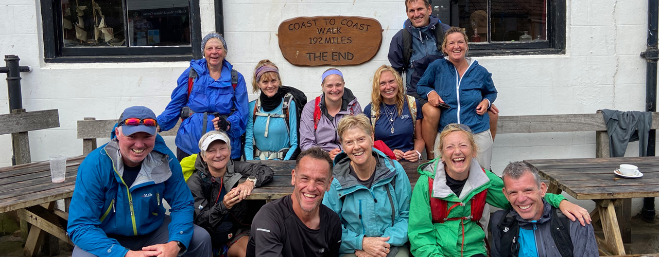
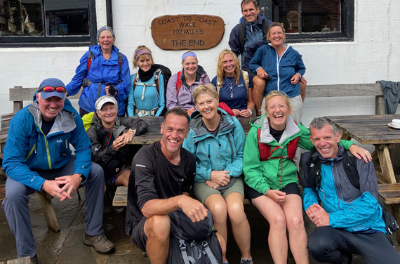
Transfer back to Grosmont. The road climbs steeply out of Grosmont (its not called the 1 in 3 for nothing) to its high point on Sleights Moor (285M), there are wonderful views to Whitby and the sea. Still on heather moorland the route descends into Littlebeck (50M). After the woodland walk it climbs back up to 200M and crosses a final stretch of heather moorland before following country lanes to the coast. We turn south to follow the coastal path to Robin Hoods Bay and a final last descent to the sea. Follow tradition once more by dipping your boot in the sea and throwing your pebble in (that should baffle the geologists in years to come). Being built on the hillside the street from top to bottom of the village is the final steep descent/ascent on route. Your challenge is complete.
Day 15 - Robin Hoods Bay
After breakfast depart for home, but first you might like to take time to explore this picturesque once fishing village and reputed smugglers haunt.
More Information?
For more information or to make an enquiry, please don't hesitate to call or email us.
