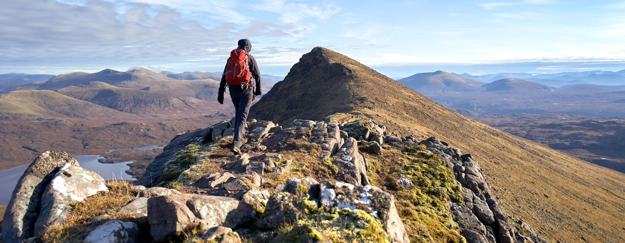
- Guided Walking Holidays
-
Guided Walking Holidays
Guided walking holidays on Wainright's Coast to Coast and the West Highland Way.
-
- Self-Guided Walking Holidays
-
Self-Guided Walking Holidays
Self-Guided walking holidays on some of the UK’s most popular routes.
-
- FAQs
- Make Booking
- Contact Us
Northwestwalks, for walking holidays you can trust
-
6 Nights Accommodation/5 Days Walking
-
St Cuthberts Way
6 Nights/5 Days Itinerary- 6 Nights Accommodation
- 5 Days Walking
- Total distance 62 miles

6 Nights Accommodation/5 Days Walking
- Day 1 Travel to Melrose where your first nights accommodation is booked
- Day 2 Melrose to Harestanes - 15 miles
- Day 3 Harestanes to Kirk Yetholm - 16 miles
- Day 4 Kirk Yetholm to Wooler - 13 miles
- Day 5 Wooler to Fenwick - 12 miles
- Day 6 Fenwick to Holy Island - 6 miles
- Day 7 Depart Holy Island for home
Route Description
Melrose (height above sea level 85m) to Harestanes (60m). Distance 15 miles.
St. Cuthbert's Way starts at the gates of the magnificent ruin of 12th century Melrose Abbey in the Borders town of Melrose. From Melrose, a steep climb takes you over the saddle (310m) between the Eildon Hills. There are wonderful views in every direction. The route descends to the village of Bowden and leads you through farmland and woodland to Newtown St Boswells. A short walk along the banks of the River Tweed takes you into St. Boswells (90m). You continue along the banks of the River Tweed for a short distance then walk across farmland to follow Dere Street, you will be following in the footsteps of the Romans who built the original road, now a tree lined grassy track across the undulating landscape to Harestanes Countryside Visitor Centre.
Harestanes (60m) to Kirk Yetholm (100m). Distance 16 miles.
You re-join the route at Harestanes and pass Monteviot House then cross the River Teviot. After a short walk along the river you follow paths across farmland and open moor to the village of Cessford and the ruins of Cessford Castle, once the stronghold of the Kers, notorious Border Reivers. The route now follows country lanes through the village of Morebattle (95m). St. Cuthbert’s Way now takes a route over the hills to Kirk Yetholm; this is regarded as the hardest section of the walk. You follow paths as you climb Grubbit Law and cross Wideopen Hill (368M), the highest point on St. Cuthbert’s Way, then Crookedshaws Hill before descending to Kirk Yetholm. Kirk Yetholm is the northern most point on the Pennine Way and you may meet walkers finishing or are about to start the 268 mile route across the rugged backbone of England.
Kirk Yetholm (100m) to Wooler (50m). Distance 13 miles.
The route leaves Kirk Yetholm along a short section of the Pennine Way. You climb and cross the hills (340m) to Hethpool (120m), passing one of many hillforts along St. Cuthbert’s Way and crossing the border from Scotland into England. At the border you will cross into Northumberland National Park, one of Britain’s best kept secrets. Then it’s on through woodland and a good track along the Cheviot foothills. The route rises to 340 metres and you cross the hills to the small market town of Wooler, where you will find shops, cafes and pubs.
Wooler (50m) to Fenwick (40m). Distance 12 miles.
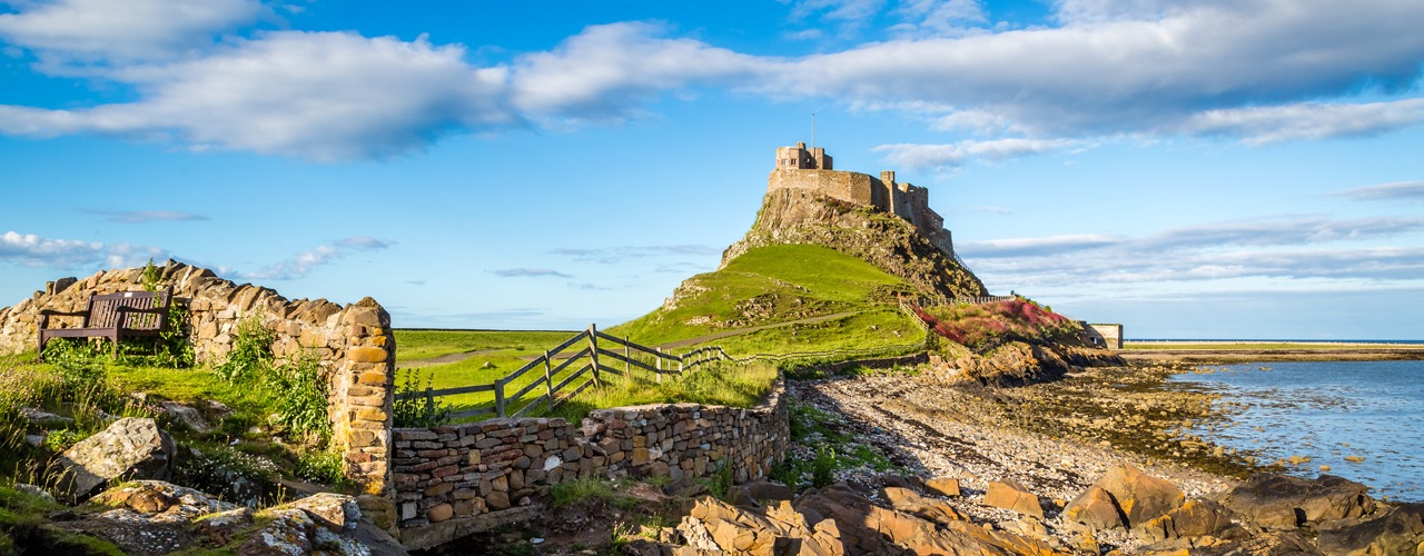
Between Wooler to Fenwick the terrain is easier as St Cuthbert’s Way crosses rolling hills. You leave Wooler and follow paths over Weetwood Moor (150m), quiet lanes then lead to Horton. Paths and tracks lead across farmland to woodland owned and managed by the National Trust. Here you will find St. Cuthbert’s Cave, a sandstone cave where monks took St. Cuthbert’s body in 875AD as they fled from repeated Viking raids on Lindisfarne. After a short uphill walk you get your first view of Holy Island and Lindisfarne Castle. The route leads you into woodland and onto the village of Fenwick. There is a scattering of nearby accommodation.
Fenwick (40m) to Holy Island (15m). Distance 6 miles.
From Fenwick it is a few miles across farmland to the Causeway, which can be crossed at low tide to Holy Island. Plan your day so you arrive to walk over to the island when the tide is out and it is safe to cross. Having reached the Causeway you can either cross via the Causeway Road or follow the posts of the historic Pilgrims Path across the sands. Once on the island it is a short walk to the village and the end of St. Cuthbert’s Way. Here you can see the ruins of the Priory and view Lindisfarne Castle.
Booking
Our self guided holidays are booked on an individual basis and therefore you can start your holiday on any date of your choice between April and early October.
This Holiday Includes
6 nights accommodation with breakfast
Daily luggage transfer between accommodation
Guidebook & route map
Accommodation directions & holiday information
Emergency contact
Holiday price £740 per person based on two people sharing a room. Single supplement £330.
-
St Cuthberts Way
5 Nights/4 Days Itinerary- 5 Nights Accommodation
- 4 Days Walking
- Total distance 62 miles
5 Nights Accommodation/4 Days Walking
- Day 1 Travel to Melrose where your first nights accommodation is booked
- Day 2 Melrose to Harestanes - 15 miles
- Day 3 Harestanes to Kirk Yetholm - 16 miles
- Day 4 Kirk Yetholm to Wooler - 13 miles
- Day 5 Wooler to Holy Island - 18 miles
- Day 6 Depart Holy Island for home
Route Description
Melrose (height above sea level 85m) to Harestanes (60m). Distance 15 miles.
St. Cuthbert's Way starts at the gates of the magnificent ruin of 12th century Melrose Abbey in the Borders town of Melrose. From Melrose, a steep climb takes you over the saddle (310m) between the Eildon Hills. There are wonderful views in every direction. The route descends to the village of Bowden and leads you through farmland and woodland to Newtown St Boswells. A short walk along the banks of the River Tweed takes you into St. Boswells (90m). You continue along the banks of the River Tweed for a short distance then walk across farmland to follow Dere Street, you will be following in the footsteps of the Romans who built the original road, now a tree lined grassy track across the undulating landscape to Harestanes Countryside Visitor Centre.
Harestanes (60m) to Kirk Yetholm (100m). Distance 16 miles.
You re-join the route at Harestanes and pass Monteviot House then cross the River Teviot. After a short walk along the river you follow paths across farmland and open moor to the village of Cessford and the ruins of Cessford Castle, once the stronghold of the Kers, notorious Border Reivers. The route now follows country lanes through the village of Morebattle (95m). St. Cuthbert’s Way now takes a route over the hills to Kirk Yetholm; this is regarded as the hardest section of the walk. You follow paths as you climb Grubbit Law and cross Wideopen Hill (368M), the highest point on St. Cuthbert’s Way, then Crookedshaws Hill before descending to Kirk Yetholm. Kirk Yetholm is the northern most point on the Pennine Way and you may meet walkers finishing or are about to start the 268 mile route across the rugged backbone of England.
Kirk Yetholm (100m) to Wooler (50m). Distance 13 miles.
The route leaves Kirk Yetholm along a short section of the Pennine Way. You climb and cross the hills (340m) to Hethpool (120m), passing one of many hillforts along St. Cuthbert’s Way and crossing the border from Scotland into England. At the border you will cross into Northumberland National Park, one of Britain’s best kept secrets. Then it’s on through woodland and a good track along the Cheviot foothills. The route rises to 340 metres and you cross the hills to the small market town of Wooler, where you will find shops, cafes and pubs.
Wooler (50m) to Holy Island (15m). Distance 18 miles.
Between Wooler to Fenwick the terrain is easier as St Cuthbert’s Way crosses rolling hills. You leave Wooler and follow paths over Weetwood Moor (150m), quiet lanes then lead to Horton. Paths and tracks lead across farmland to woodland owned and managed by the National Trust. Here you will find St. Cuthbert’s Cave, a sandstone cave where monks took St. Cuthbert’s body in 875AD as they fled from repeated Viking raids on Lindisfarne. After a short uphill walk you get your first view of Holy Island and Lindisfarne Castle. The route leads you into woodland and onto the village of Fenwick. From Fenwick it is a few miles across farmland to the Causeway, which can be crossed at low tide to Holy Island. Plan your day so you arrive to walk over to the island when the tide is out and it is safe to cross. Having reached the Causeway you can either cross via the Causeway Road or follow the posts of the historic Pilgrims Path across the sands. Once on the island it is a short walk to the village and the end of St. Cuthbert’s Way. Here you can see the ruins of the Priory and view Lindisfarne Castle.
Booking
Our self guided holidays are booked on an individual basis and therefore you can start your holiday on any date of your choice between April and early October.
This Holiday Includes
5 nights accommodation with breakfast
Daily luggage transfer between accommodation
Guidebook & route map
Accommodation directions & holiday information
Emergency contact
Holiday price £625 per person based on two people sharing a room. Single supplement £275.
-

West Highland Way
10 Nights/9 Days Itinerary- 10 Nights Accommodation
- 9 Days Walking
- Total distance 96 miles
10 Nights Accommodation/9 Days Walking
- Day 1 Travel to Milngavie where your first nights accommodation is booked
- Day 2 Milngavie to Drymen - 12 miles
- Day 3 Drymen to Balmaha - 8 miles
- Day 4 Balmaha to Rowardennan - 7 miles
- Day 5 Rowardennan to Inverarnan - 14 miles
- Day 6 Inverarnan to Tyndrum - 12 miles
- Day 7 Tyndrum to Bridge of Orchy/Inveroran - 7/10 miles
- Day 8 Bridge of Orchy/Inveroran to Kingshouse - 12/9 miles
- Day 9 Kingshouse to Kinlochleven - 9 miles
- Day 10 Kinlochleven to Fort William - 15 miles
- Day 11 Depart Fort William for home
Route Description
Milngavie (50m) to Drymen (50m). Distance 12 miles
The official start of the West Highland Way is a granite obelisk in Douglas Street, Milngavie. The Way leaves the town centre and enters Mugdock Country Park. On leaving the park the route continues northwards on good paths through rolling farmland. On route to Drymen the way route passes through Dumgoyne village.
Drymen (50m) to Balmaha (20m). Distance 8 miles
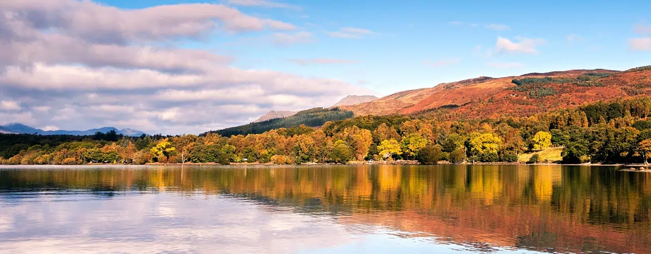
The Way enters Garadhban Forest and follows a forest track for a few miles. Upon leaving the forest you can either follow the alternative route to Milton of Buchan and then the road to Balmaha, or follow the path as is climbs almost to the summit of Conic Hill (360m), on a clear day there are wonderful views over Loch Lomond. The Way then descends to Balmaha, and passes the National Park Centre.
Balmaha (20m) to Rowardennan (20m). Distance 7 miles
A woodland walk along good paths or tracks for most of the route but it can be twisty and undulating in places. The Way runs close to the eastern shore of Loch Lomond.
Rowardennan (20m) to Inverarnan (30m). Distance 14 miles
The Way follows a forestry track for approx 2 miles to Ptarmigan Lodge, 300m further on the Way divides. The right hand, higher path follows a forest track and is easier going. The lower route goes down steep stone steps toward the shoreline. It is hard going in places; sometimes steep above the loch and sometimes scrambling among boulders.
The two paths run for 4 miles then converge and continue through pleasant woodland, for a further 3 miles to Inversnaid.
The Way then continues along the side of the loch but the going is more difficult and the path for the next few miles is regarded as one of the toughest sections of the Way. Two miles before Inverarnan the going is much easier.
Inverarnan (30m) to Tyndrum (225m). Distance 12 miles
The Way continues along good paths and tracks, much of which is an old military road. This is the gateway to the Highlands and the Way gains height as it leaves the Loch Lomond basin and rises to 250m. Initially through a forest the way continues along good paths and tracks with some moderate descents and ascents on route to Tyndrum.
Tyndrum (225m) to Bridge of Orchy (160m)/Inveroran (180m). Distance 7 or 10 miles
The Way continues for 7 miles along good paths and tracks following the line of an old military road to the Bridge of Orchy. Depending on availability accommodation is either booked at Bridge of Orchy or Inveroran, which is another 3 miles along the Way.
Bridge of Orchy (160m)/Inveroran (180m) to Kingshouse (250m). Distance 12 or 9 miles
Bridge of Orchy (160m)/Inveroran (180m) to Kingshouse (250m). Distance 12 or 9 miles
There is good going underfoot as you cross Rannoch Moor, one of Britain’s largest and wildest moors. The path climbs steadily to its high point at 450m before descending to Kingshouse. The scenery is spectacular but you are highly exposed and in bad weather this can be a very tough stage of the Way.
Kingshouse (250m) to Kinlochleven (20m). Distance 9 miles
The Way follows the route of an old military road. 3 miles beyond Kingshouse the Way climbs steeply up the Devils Staircase. At 550m this is the highest point on the Way. There is now a long descent into Kinlochleven. This again is a hard and exposed stage in bad weather.
Kinlochleven (20m) to Fort William (10m) Distance 15 miles
In the first mile the Way zigzags steeply up the hillside to meet an old military road (250m). The highest point on todays route is Lairigmor, the high pass (330m), though there are no more serious gradients as the route continues on good paths with high mountains on both sides. The final stretch is a bit of rough walking through Nevis Forest, with Ben Nevis visible through breaks in the trees. The Way descends into Glen Nevis and follows a road for the final 1.5miles to Fort William and the end of a wonderful route.
Booking
Our self guided holidays are booked on an individual basis and therefore you can start your holiday on any date of your choice between April and early October.
This Holiday Includes
10 nights accommodation with breakfast
Daily luggage transfer between accommodation
Guidebook & route map
Accommodation directions & holiday information
Emergency contact
Holiday price £1300 per person based on two people sharing a room. Single supplement £900.
-
West Highland Way
9 Nights/8 Days Itinerary- 9 Nights Accommodation
- 8 Days Walking
- Total distance 96 miles
9 Nights Accommodation/8 Days Walking
- Day 1 Travel to Milngavie where your first nights accommodation is booked
- Day 2 Milngavie to Drymen - 12 miles
- Day 3 Drymen to Rowardennan - 15 miles
- Day 4 Rowardennan to Inverarnan - 14 miles
- Day 5 Inverarnan to Tyndrum - 12 miles
- Day 6 Tyndrum to Bridge of Orchy/Inveroran - 7/10 miles
- Day 7 Bridge of Orchy/Inveroran to Kingshouse - 12/9 miles
- Day 8 Kingshouse to Kinlochleven - 9 miles
- Day 9 Kinlochleven to Fort William - 15 miles
- Day 10 Depart Fort William for home
Route Description
Milngavie (50m) to Drymen (50m). Distance 12 miles
The official start of the West Highland Way is a granite obelisk in Douglas Street, Milngavie. The Way leaves the town centre and enters Mugdock Country Park. On leaving the park the route continues northwards on good paths through rolling farmland. On route to Drymen the way route passes through Dumgoyne village.
Drymen (50m) to Rowardennan (20m). Distance 15 miles
The Way enters Garadhban Forest and follows a forest track for a few miles. Upon leaving the forest you can either follow the alternative route to Milton of Buchan and then the road to Balmaha, or follow the path as is climbs almost to the summit of Conic Hill (360m), on a clear day there are wonderful views over Loch Lomond. The Way then descends to Balmaha, and passes the National Park Centre. A woodland walk along good paths or tracks for most of the route but it can be twisty and undulating in places. The Way runs close to the eastern shore of Loch Lomond.
Rowardennan (20m) to Inverarnan (30m). Distance 14 miles
The Way follows a forestry track for approx 2 miles to Ptarmigan Lodge, 300m further on the Way divides. The right hand, higher path follows a forest track and is easier going. The lower route goes down steep stone steps toward the shoreline. It is hard going in places; sometimes steep above the loch and sometimes scrambling among boulders.
The two paths run for 4 miles then converge and continue through pleasant woodland, for a further 3 miles to Inversnaid.
The Way then continues along the side of the loch but the going is more difficult and the path for the next few miles is regarded as one of the toughest sections of the Way. Two miles before Inverarnan the going is much easier.
Inverarnan (30m) to Tyndrum (225m). Distance 12 miles
The Way continues along good paths and tracks, much of which is an old military road. This is the gateway to the Highlands and the Way gains height as it leaves the Loch Lomond basin and rises to 250m. Initially through a forest the way continues along good paths and tracks with some moderate descents and ascents on route to Tyndrum.
Tyndrum (225m) to Bridge of Orchy (160m)/Inveroran (180m). Distance 7 or 10 miles.
The Way continues for 7 miles along good paths and tracks following the line of an old military road to the Bridge of Orchy. Depending on availability accommodation is either booked at Bridge of Orchy or Inveroran, which is another 3 miles along the Way.
Bridge of Orchy (160m)/Inveroran (180m) to Kingshouse (250m). Distance 12 or 9 miles
There is good going underfoot as you cross Rannoch Moor, one of Britain’s largest and wildest moors. The path climbs steadily to its high point at 450m before descending to Kingshouse. The scenery is spectacular but you are highly exposed and in bad weather this can be a very tough stage of the Way.
Kingshouse (250m) to Kinlochleven (20m). Distance 9 miles
The Way follows the route of an old military road. 3 miles beyond Kingshouse the Way climbs steeply up the Devils Staircase. At 550m this is the highest point on the Way. There is now a long descent into Kinlochleven. This again is a hard and exposed stage in bad weather.
Kinlochleven (20m) to Fort William (10m) Distance 15 miles
In the first mile the Way zigzags steeply up the hillside to meet an old military road (250m). The highest point on todays route is Lairigmor, the high pass (330m), though there are no more serious gradients as the route continues on good paths with high mountains on both sides. The final stretch is a bit of rough walking through Nevis Forest, with Ben Nevis visible through breaks in the trees. The Way descends into Glen Nevis and follows a road for the final 1.5miles to Fort William and the end of a wonderful route.
Booking
Our self guided holidays are booked on an individual basis and therefore you can start your holiday on any date of your choice between April and early October.
This Holiday Includes
- 9 nights accommodation with breakfast
- Daily luggage transfer between accommodation
- Guidebook & route map
- Accommodation directions & holiday information
- Emergency contact
- Holiday price £1180 per person based on two people sharing a room. Single supplement £810.
-
West Highland Way
8 Nights/7 Days Itinerary- 8 Nights Accommodation
- 7 Days Walking
- Total distance 96 miles
8 Nights Accommodation/7 Days Walking
- Day 1 Travel to Milngavie where your first nights accommodation is booked
- Day 2 Milngavie to Drymen - 12 miles
- Day 3 Drymen to Rowardennan - 15 miles
- Day 4 Rowardennan to Inverarnan - 14 miles
- Day 5 Inverarnan to Tyndrum - 12 miles
- Day 6 Tyndrum to Kingshouse - 19 miles
- Day 7 Kingshouse to Kinlochleven - 9 miles
- Day 8 Kinlochleven to Fort William - 15 miles
- Day 9 Depart Fort William for home
Route Description
Milngavie (50m) to Drymen (50m). Distance 12 miles
The official start of the West Highland Way is a granite obelisk in Douglas Street, Milngavie. The Way leaves the town centre and enters Mugdock Country Park. On leaving the park the route continues northwards on good paths through rolling farmland. On route to Drymen the way route passes through Dumgoyne village.
Drymen (50m) to Rowardennan (20m). Distance 15 miles
The Way enters Garadhban Forest and follows a forest track for a few miles. Upon leaving the forest you can either follow the alternative route to Milton of Buchan and then the road to Balmaha, or follow the path as is climbs almost to the summit of Conic Hill (360m), on a clear day there are wonderful views over Loch Lomond. The Way then descends to Balmaha, and passes the National Park Centre. A woodland walk along good paths or tracks for most of the route but it can be twisty and undulating in places. The Way runs close to the eastern shore of Loch Lomond.
Rowardennan (20m) to Inverarnan (30m). Distance 14 miles
The Way follows a forestry track for approx 2 miles to Ptarmigan Lodge, 300m further on the Way divides. The right hand, higher path follows a forest track and is easier going. The lower route goes down steep stone steps toward the shoreline. It is hard going in places; sometimes steep above the loch and sometimes scrambling among boulders.
The two paths run for 4 miles then converge and continue through pleasant woodland, for a further 3 miles to Inversnaid.
The Way then continues along the side of the loch but the going is more difficult and the path for the next few miles is regarded as one of the toughest sections of the Way. Two miles before Inverarnan the going is much easier.
Inverarnan (30m) to Tyndrum (225m). Distance 12 miles
The Way continues along good paths and tracks, much of which is an old military road. This is the gateway to the Highlands and the Way gains height as it leaves the Loch Lomond basin and rises to 250m. Initially through a forest the way continues along good paths and tracks with some moderate descents and ascents on route to Tyndrum.
Tyndrum (225m) to Kingshouse (250m). Distance 19 miles
The Way continues for 7 miles along good paths and tracks following the line of an old military road to the Bridge of Orchy. There is good going underfoot as you cross Rannoch Moor, one of Britain’s largest and wildest moors. The path climbs steadily to its high point at 450m before descending to Kingshouse. The scenery is spectacular but you are highly exposed and in bad weather this can be a very tough stage of the Way.
Kingshouse (250m) to Kinlochleven (20m). Distance 9 miles
The Way follows the route of an old military road. 3 miles beyond Kingshouse the Way climbs steeply up the Devils Staircase. At 550m this is the highest point on the Way. There is now a long descent into Kinlochleven. This again is a hard and exposed stage in bad weather.
Kinlochleven (20m) to Fort William (10m) Distance 15 miles
In the first mile the Way zigzags steeply up the hillside to meet an old military road (250m). The highest point on todays route is Lairigmor, the high pass (330m), though there are no more serious gradients as the route continues on good paths with high mountains on both sides. The final stretch is a bit of rough walking through Nevis Forest, with Ben Nevis visible through breaks in the trees. The Way descends into Glen Nevis and follows a road for the final 1.5miles to Fort William and the end of a wonderful route.
Booking
Our self guided holidays are booked on an individual basis and therefore you can start your holiday on any date of your choice between April and early October.
This Holiday Includes
7 nights accommodation with breakfast
Daily luggage transfer between accommodation
Guidebook & route map
Accommodation directions & holiday information
Emergency contact
Holiday price £1005 per person based on two people sharing a room. Single supplement £720.
-
West Highland Way
7 Nights/6 Days Itinerary- 7 Nights Accommodation
- 6 Days Walking
- Total distance 96 miles
7 Nights Accommodation/6 Days Walking
- Day 1 Travel to Milngavie where your first nights accommodation is booked
- Day 2 Milngavie to Drymen - 12 miles
- Day 3 Drymen to Rowardennan - 15 miles
- Day 4 Rowardennan to Crianlarich - 20 miles
- Day 5 Crianlarich to Bridge of Orchy/Inveroran - 13/16 miles
- Day 6 Bridge of Orchy/Inveroran to Kinlochleven - 21/18 miles
- Day 7 Kinlochleven to Fort William - 15 miles
- Day 8 Depart Fort William for home
Route Description
Milngavie (50m) to Drymen (50m). Distance 12 miles
The official start of the West Highland Way is a granite obelisk in Douglas Street, Milngavie. The Way leaves the town centre and enters Mugdock Country Park. On leaving the park the route continues northwards on good paths through rolling farmland. On route to Drymen the way route passes through Dumgoyne village.
Drymen (50m) to Rowardennan (20m). Distance 15 miles
The Way enters Garadhban Forest and follows a forest track for a few miles. Upon leaving the forest you can either follow the alternative route to Milton of Buchan and then the road to Balmaha, or follow the path as is climbs almost to the summit of Conic Hill (360m), on a clear day there are wonderful views over Loch Lomond. The Way then descends to Balmaha, and passes the National Park Centre. A woodland walk along good paths or tracks for most of the route but it can be twisty and undulating in places. The Way runs close to the eastern shore of Loch Lomond.
Rowardennan (20m) to Crianlarich (180m). Distance 20 miles
The Way follows a forestry track for approx 2 miles to Ptarmigan Lodge, 300m further on the Way divides. The right hand, higher path follows a forest track and is easier going. The lower route goes down steep stone steps toward the shoreline. It is hard going in places; sometimes steep above the loch and sometimes scrambling among boulders. The two paths run for 4 miles then converge and continue through pleasant woodland, for a further 3 miles to Inversnaid. The Way then continues along the side of the loch but the going is more difficult and the path for the next few miles is regarded as one of the toughest sections of the Way. Two miles before Inverarnan the going is much easier. The Way continues along good paths and tracks, much of which is an old military road. This is the gateway to the Highlands and the Way gains height as it leaves the Loch Lomond basin and rises to 250m. Crianlarich is 0.5 miles off the main route.
Crianlarich (180m).to Bridge of Orchy (160m)/Inveroran (180m). Distance 13 or 16 miles.
Initially through a forest the way continues along good paths and tracks with some moderate descents and ascents on route to Tyndrum. From Tyndrum The Way continues for 7 miles along good paths and tracks following the line of an old military road to the Bridge of Orchy. Depending on availability accommodation is either booked at Bridge of Orchy or Inveroran, which is another 3 miles along the Way.
Bridge of Orchy (160m)/Inveroran (180m) to Kinlochleven (20m). Distance 21 or 18 miles
There is good going underfoot as you cross Rannoch Moor, one of Britain’s largest and wildest moors. The path climbs steadily to its high point at 450m before descending to Kingshouse. The scenery is spectacular, but you are highly exposed and in bad weather this can be a very tough stage of the Way. From Kingshouse The Way follows the route of an old military road. 3 miles beyond Kingshouse the Way climbs steeply up the Devils Staircase. At 550m this is the highest point on the Way. There is now a long descent into Kinlochleven. This again is a hard and exposed stage in bad weather.
Kinlochleven (20m) to Fort William (10m) Distance 15 miles
In the first mile the Way zigzags steeply up the hillside to meet an old military road (250m). The highest point on todays route is Lairigmor, the high pass (330m), though there are no more serious gradients as the route continues on good paths with high mountains on both sides. The final stretch is a bit of rough walking through Nevis Forest, with Ben Nevis visible through breaks in the trees. The Way descends into Glen Nevis and follows a road for the final 1.5miles to Fort William and the end of a wonderful route.
Booking
Our self guided holidays are booked on an individual basis and therefore you can start your holiday on any date of your choice between April and early October.
This Holiday Includes
- 7 nights accommodation with breakfast
- Daily luggage transfer between accommodation
- Guidebook & route map
- Accommodation directions & holiday information
- Emergency contact
- Holiday price £880 per person based on two people sharing a room. Single supplement £630.
-
West Highland Way
6 Nights/5 Days Itinerary- 6 Nights Accommodation
- 5 Days Walking
- Total distance 96 miles
6 Nights Accommodation/5 Days Walking
- Day 1 Travel to Milngavie where your first nights accommodation is booked
- Day 2 Milngavie to Balmaha - 20 miles
- Day 3 Balmaha to Inverarnan - 21 miles
- Day 4 Inverarnan to Bridge of Orchy/Inveroran - 19/22 miles
- Day 5 Bridge of Orchy/Inveroran to Kinlochleven - 21/18 miles
- Day 6 Kinlochleven to Fort William - 15 miles
- Day 7 Depart Fort William for home
Route Description
Milngavie (50m) to Balmaha (20m). Distance 20 miles
The official start of the West Highland Way is a granite obelisk in Douglas Street, Milngavie. The Way leaves the town centre and enters Mugdock Country Park. On leaving the park the route continues northwards on good paths through rolling farmland. On route to Drymen the way route passes through Dumgoyne village. From Drymen The Way enters Garadhban Forest and follows a forest track for a few miles. Upon leaving the forest you can either follow the alternative route to Milton of Buchan and then the road to Balmaha, or follow the path as is climbs almost to the summit of Conic Hill (360m), on a clear day there are wonderful views over Loch Lomond. The Way then descends to Balmaha, and passes the National Park Centre.
Balmaha (20m) to Inverarnan (30m). Distance 21 miles
A woodland walk along good paths or tracks for most of the route but it can be twisty and undulating in places. The Way runs close to the eastern shore of Loch Lomond passing Rowardennan. The Way follows a forestry track for approx. 2 miles to Ptarmigan Lodge, 300m further on the Way divides. The right hand, higher path follows a forest track and is easier going. The lower route goes down steep stone steps toward the shoreline. It is hard going in places; sometimes steep above the loch and sometimes scrambling among boulders. The two paths run for 4 miles then converge and continue through pleasant woodland, for a further 3 miles to Inversnaid. The Way then continues along the side of the loch but the going is more difficult and the path for the next few miles is regarded as one of the toughest sections of the Way. Two miles before Inverarnan the going is much easier.
Inverarnan (30m) to Bridge of Orchy (160m)/Inveroran (180m). Distance 19 or 22 miles.
The Way continues along good paths and tracks, much of which is an old military road. This is the gateway to the Highlands and the Way gains height as it leaves the Loch Lomond basin and rises to 250m. Initially through a forest the way continues along good paths and tracks with some moderate descents and ascents on route to Tyndrum. From Tyndrum The Way continues for 7 miles along good paths and tracks following the line of an old military road to the Bridge of Orchy. Depending on availability accommodation is either booked at Bridge of Orchy or Inveroran, which is another 3 miles along the Way.
Bridge of Orchy (160m)/Inveroran (180m) to Kinlochleven (20m). Distance 21 or 18 miles
There is good going underfoot as you cross Rannoch Moor, one of Britain’s largest and wildest moors. The path climbs steadily to its high point at 450m before descending to Kingshouse. The scenery is spectacular, but you are highly exposed and in bad weather this can be a very tough stage of the Way. From Kingshouse The Way follows the route of an old military road. 3 miles beyond Kingshouse the Way climbs steeply up the Devils Staircase. At 550m this is the highest point on the Way. There is now a long descent into Kinlochleven. This again is a hard and exposed stage in bad weather.
Kinlochleven (20m) to Fort William (10m) Distance 15 miles
In the first mile the Way zigzags steeply up the hillside to meet an old military road (250m). The highest point on todays route is Lairigmor, the high pass (330m), though there are no more serious gradients as the route continues on good paths with high mountains on both sides. The final stretch is a bit of rough walking through Nevis Forest, with Ben Nevis visible through breaks in the trees. The Way descends into Glen Nevis and follows a road for the final 1.5miles to Fort William and the end of a wonderful route.
Booking
Our self guided holidays are booked on an individual basis and therefore you can start your holiday on any date of your choice between April and early October.
This Holiday Includes
- 6 nights accommodation including breakfast
- Baggage transfer along the route
- 5 days walking
- Total distance 96 miles
- Average daily distance 19 miles
- Shortest day 15 miles
- Longest day 22 miles
- Cost £810/person (single supplement* £540/person)