- Guided Walking Holidays
-
Guided Walking Holidays
Guided walking holidays on Wainright's Coast to Coast and the West Highland Way.
-
- Self-Guided Walking Holidays
-
Self-Guided Walking Holidays
Self-Guided walking holidays on some of the UK’s most popular routes.
-
- FAQs
- Make Booking
- Contact Us
Northwestwalks, for walking holidays you can trust
-
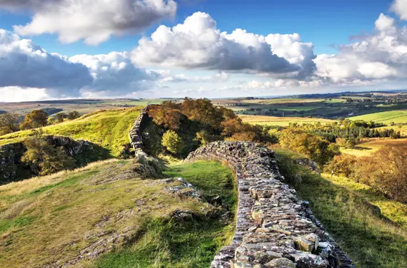
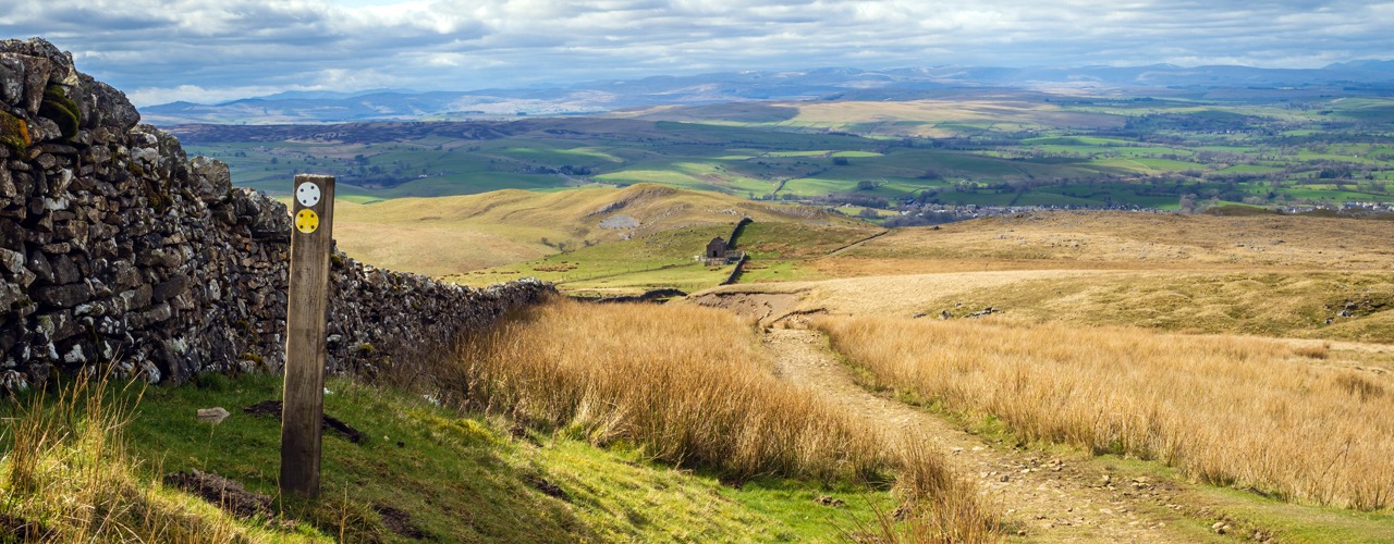
Experience the West-to-East Hadrian’s Wall Walking Adventure
Home ›
-
Experience the Hadrian’s Wall Walking Adventure
Home › Articles by: Dean Halsall
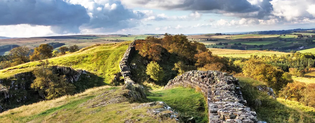
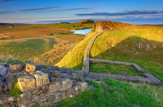
Walking the Hadrian's Wall Path: A West to East Adventure
Why Walk Hadrian’s Wall from West to East?
While you can walk the path in either direction, heading west to east has its unique charm. Starting at the Irish Sea and ending near the North Sea provides a satisfying sense of crossing the country. The prevailing winds are often at your back, making the journey easier. This route also saves the most dramatic sections of the wall for the middle of your walk, ensuring the trip builds to a memorable crescendo.
The Allure of the Hadrian’s Wall Path
Walking the Hadrian’s Wall Path isn’t just a physical journey—it’s a chance to immerse yourself in the heritage and beauty of northern England. You’ll pass ancient Roman forts, rolling countryside, rugged moorlands, and bustling towns along the way. Each step is an opportunity to connect with history, marvel at nature, and experience the unique charm of the local communities.
Tips for Walking Hadrian’s Wall West to East
- Prepare for All Weathers: Northern England is known for unpredictable weather. Layers, waterproofs, and sturdy walking boots are essential.
- Pace Yourself: The path offers a mix of terrains, from gentle riverside trails to steeper climbs. Tailor your itinerary to your fitness level.
- Immerse Yourself in History: Take time to explore the forts, museums, and information boards along the route.
- Book Accommodation Early: Popular stops along the trail can fill up quickly, especially in peak season.
- Stay Hydrated and Snack Smart: Pack plenty of water and high-energy snacks to keep you fueled on longer stretches.
Ready to Walk the Hadrian’s Wall Path?
Walking the Hadrian’s Wall Path west to east is a journey through time and nature that will leave you with memories to treasure. Whether you’re seeking solitude, adventure, or a deep dive into history, this trail offers it all.
Contact us today to start planning your perfect Hadrian’s Wall walking holiday – your Roman adventure awaits!
Get in touch
If you have questions regarding any of our holidays, please feel free to contact us. Your questions are always welcome.
Email: nww@northwestwalks.co.uk
Telephone: +44 (0)1257 424889
-
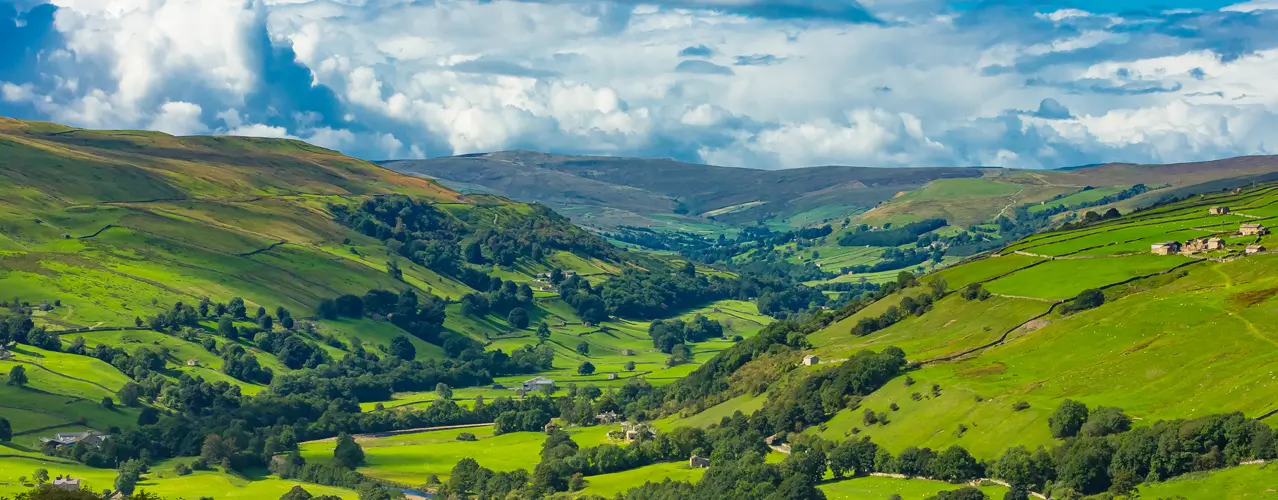
The Ultimate Guide to the West Highland Way
Home › Articles by: Dean Halsall
5 Questions About the West Highland Way: Your Ultimate Guide
Scotland's West Highland Way is a mesmerising adventure that beckons nature enthusiasts and hikers from around the globe. As you contemplate embarking on this epic journey, it's natural to have questions about what to expect, how to prepare, and what makes this trail so special. In this blog post, we'll answer five of the most common questions about the West Highland Way, offering insights and tips to help you plan the ultimate walking holiday.
1. What is the West Highland Way, and Why Hike It?
The West Highland Way is Scotland's premier long-distance hiking trail, spanning approximately 96 miles from Milngavie to Fort William. It offers an extraordinary trek through some of the UK’s most beautiful and rugged landscapes. This journey is not just about the destination; it's about immersing yourself in the untamed beauty of the Scottish Highlands, connecting with history, and experiencing the warm hospitality of its people.
2. How Long Does it Take to Complete the West Highland Way?
The average hiker takes about 7-8 days to complete the West Highland Way, we offer itineraries from 5 to 9 days walking. The pace at which you tackle the trail depends on your fitness level, hiking experience, and how much time you want to spend at each stop. Remember, it's not a race; it's an adventure, so take your time and soak in the breathtaking landscapes.
3. When is the Best Time to Hike the West Highland Way?
We operate West Highland Way holidays from April to October. The most popular months being May and September, but the best time to hike it largely depends on your preferences.
4. Do I Need to Be an Experienced Hiker?
The trail offers a mix of terrains, from well-maintained paths to challenging ascents and descents. Make sure to prepare physically by walking or hiking in the lead-up to your trip and breaking in your hiking boots.
5. What Should I Pack and Prepare for the West Highland Way?
Your packing list should include essentials like suitable clothing for various weather conditions, comfortable and waterproof hiking boots, a backpack, navigation tools, first aid supplies, and a detailed map and guidebook. Familiarise yourself with Leave No Trace principles to ensure responsible hiking and environmental stewardship.
Our Summary
The West Highland Way is a journey like no other, a trek that will immerse you in Scotland's enchanting landscapes, history, and culture. As you prepare to embark on this unforgettable adventure, these answers to common questions should help you confidently plan your trip. The West Highland Way promises a life-changing experience where the call of the wild and the charm of Scotland will leave an indelible mark on your heart. Get ready to embark on an adventure of a lifetime along this iconic trail, and let the magic of the Scottish Highlands enchant you.
If you have any questions about walking holidays on the West Highland Way, please contact us on nww@northwestwalks.co.uk
Get in touch
If you have questions regarding any of our holidays, please feel free to contact us. Your questions are always welcome.
Email: nww@northwestwalks.co.uk
Telephone: +44 (0)1257 424889
-
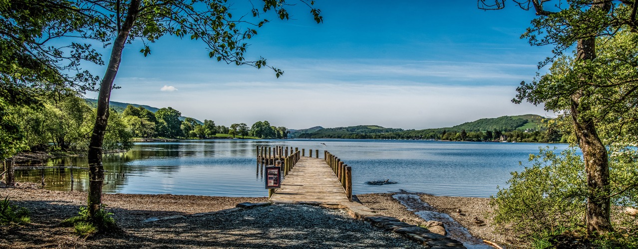
Discover the UK's Natural Majesty: The Coast to Coast Walk

Home › Articles by: Dean Halsall
Discover the UK's Natural Majesty: The Coast to Coast Walk
If you’re seeking an unforgettable adventure that combines picturesque landscapes, rich history, and diverse cultural heritage, look no further than the Coast to Coast Walk. This iconic trail spans the width of England, taking hikers on an epic journey from the Irish Sea to the North Sea. In this article, we’ll explore why the Coast to Coast Walk should be at the top of your travel bucket list when visiting the UK.

A Trail of Endless Beauty
The Coast to Coast is a 190-mile (305-kilometer) long-distance footpath that crosses three national parks: the Lake District, the Yorkshire Dales, and the North York Moors. This route showcases the UK’s natural beauty in all its glory, from rugged mountains and tranquil lakes to rolling green hills and charming villages. You’ll traverse diverse landscapes, each more breathtaking than the last.
A Journey through History
As you walk the Coast to Coast, you’ll follow in the footsteps of history. This trail was conceived by the renowned British author and hillwalker Alfred Wainwright in 1973. Along the way, you’ll encounter ancient ruins, historic sites, and stone-built villages that glimpse England’s past.
Charming Villages and Hospitable Locals
One of the highlights of the Coast to Coast path is the opportunity to visit charming villages and interact with the friendly locals. The route passes through picturesque hamlets like Grasmere and Richmond, where you can rest, refuel, and experience the warm hospitality of the residents. These encounters add a unique cultural dimension to your journey.
Accommodation Options for Every Taste
The accommodation is a mix of B&Bs, guesthouses and traditional inns. You’ll have a comfortable base to relax after each day’s adventure.
A Physical and Mental Challenge
The Coast to Coast Walk is not just a sightseeing tour; it’s a physical and mental challenge that rewards you with a profound sense of accomplishment. The terrain varies from gentle paths to steep ascents, providing a diverse hiking experience. It’s an opportunity to push your limits and connect with nature on a deeper level.
Responsible Travel and Conservation
Walking the Coast to Coast also means being part of a responsible and sustainable travel movement. The national parks and local communities work hard to protect the environment and maintain the trail. As a responsible traveller, you can contribute to preserving these natural wonders by following Leave No Trace principles and supporting local businesses.
Our Summary
The Coast to Coast Walk is a quintessential UK hiking experience that promises adventure, history, and natural beauty in equal measure. As you traverse this iconic route, you’ll witness breathtaking landscapes, explore historical treasures and forge lasting memories and connections with the people and places you encounter along the way. Embarking on the Coast to Coast is a journey that will leave an indelible mark on your heart. So, lace up your hiking boots and prepare to be awed by the wonders of England’s coast to coast trail.
If you have any questions about walking holidays on the Coast to Coast, please contact us on nww@northwestwalks.co.uk
Get in touch
If you have questions regarding any of our holidays, please feel free to contact us. Your questions are always welcome.
Email: nww@northwestwalks.co.uk
Telephone: +44 (0)1257 424889
-
The Highlights of the Herriot Way
Home › Articles by: Dean Halsall
Exploring the Charm of Yorkshire: The Highlights of the Herriot Way
In the heart of England's enchanting Yorkshire Dales lies a hidden gem for nature enthusiasts and hikers alike. The Herriot Way is a walking trail that encapsulates the essence of this beautiful region, offering a unique blend of picturesque landscapes, charming villages, and an opportunity to immerse yourself in the world of James Herriot, the renowned veterinarian and author of 'All Creatures Great and Small.' If you're seeking an unforgettable walking holiday, the Herriot Way is the perfect choice to experience the tranquillity, beauty, and captivating history of the Yorkshire Dales.
The Herriot Way - A Brief Overview
The Herriot Way is a circular long-distance walk that takes you on a 52-mile journey through the heart of the Yorkshire Dales, with the market town of Hawes as the starting and ending point. The route was established to celebrate the life and work of James Herriot, whose tales of veterinary adventures have charmed readers and television viewers for generations.
As you embark on this walking adventure, you'll encounter stunning scenery, rolling hills, lush meadows, and quaint villages, all while paying homage to Herriot's world-famous veterinary practice. Here are some of the highlights that make the Herriot Way an unforgettable experience.
Scenic Landscapes
The Yorkshire Dales National Park is renowned for its breathtaking landscapes, and the Herriot Way offers the perfect opportunity to explore this beauty up close. You'll traverse rolling hills, cross picturesque rivers, and enjoy panoramic views of the Dales. Whether you're an experienced hiker or a casual walker, the ever-changing scenery will leave you awe-inspired.
Charming Villages
The trail leads you through a series of idyllic Yorkshire villages, each with its own unique character and history. In places like Aysgarth, Thwaite, and Askrigg, you can stop and enjoy traditional English pubs, savour delicious local cuisine, and immerse yourself in the warm hospitality of the Dales. These villages are not just waypoints but destinations in their own right, offering a taste of local life and culture.
Wildlife and Flora
The Yorkshire Dales are home to various wildlife and plant species, and the Herriot Way provides ample opportunities for birdwatching and nature appreciation. You may spot red squirrels, kestrels, and the elusive curlew while strolling through the Dales' diverse ecosystems.
Tranquility and Solitude
One of the most appealing aspects of the Herriot Way is the opportunity for solitude and quiet reflection. The trail is less crowded than some other long-distance walks, providing a sense of serenity and a connection to the natural world. The peace and tranquillity of the Dales make it a perfect destination for those looking to escape the hustle and bustle of daily life.
Our Summary
The Herriot Way is a remarkable walking holiday experience that takes you on a journey through the captivating landscapes and rich heritage of the Yorkshire Dales. Whether you're a nature lover, a history enthusiast, or simply seeking an escape to the countryside, this trail has something to offer. The opportunity to explore James Herriot's world, embrace the serene beauty of the Dales, and interact with friendly locals makes the Herriot Way an unforgettable adventure for all. So, lace up your boots and embark on this journey to discover the highlights of the Herriot Way - an experience that will leave you with memories to cherish forever.
If you have any questions about the Herriot Way Self Guided Walking Holiday, please contact us on nww@northwestwalks.co.uk
Get in touch
If you have questions regarding any of our holidays, please feel free to contact us. Your questions are always welcome.
Email: nww@northwestwalks.co.uk
Telephone: +44 (0)1257 424889
-
Cumbria Way 7 Nights/6 Days Itinerary
- 7 Nights Accommodation
- 6 Days Walking
- Total distance 70 miles

Home › Articles by: Dean Halsall
7 Nights Accommodation/6 Days Walking
- Day 1 Travel to Ulverston where your first nights accommodation is booked
- Day 2 Ulverston to Coniston - 15 miles
- Day 3 Coniston to Langdales - 11 miles
- Day 4 Langdales to Rosthwaite - 8 miles
- Day 5 Rosthwaite to Keswick - 8 miles
- Day 6 Keswick to Caldbeck - 15 miles
- Day 7 Caldbeck to Carlisle - 14 miles
- Day 8 Depart Carlisle for home
Route Description
Ulverston (height above sea level 50m) to Coniston (60m). Distance 15 miles
The route leaves the Ulverston, birthplace of Stan Laurel, and heads north across farmland climbing to Higher Lath Farm (170m) then descending to pass St John’s Church in the hamlet of Broughton Beck (100m). Continuing across farmland the route enters the Lake District National Park near Gawthwaite (160m). The route continues passing farms and small hamlets to Tottlebank (145m) where it crosses low lying fells, passing Beacon Tarn (170m) on the way, before descending to Coniston Water (50m). The route follows a path along the western shore of Coniston Water to Coniston village (60m), in the shadow of Coniston Old Man fell.
Coniston (60m) to Langdale (90m). Distance 11 miles
The route leaves Coniston and climbs through woodland and fields to the stunning Tarn Hows. The route passes the tarn and joins a track through areas of woodland. It passes Great How and turns right to the villages of Colwith and Skelwith Bridge. The Langdale Pikes soon become visible as the route leaves Skelwith Bridge (50m). The route then turns left to follow the beck to the village of Elterwater before entering the Great Langdale valley. The route follows close to Great Langdale Beck, there are wonderful views on the fells on either side of the valley to Dungeon Ghyll (90M).
Langdale (90m) to Rosthwaite (100m). Distance 8 miles
The route follows Mickleden Beck below the Langdale Pikes. The route climbs gradually at first then it turns north and climbs steeply alongside Stake Gill. It crosses the fell via Stake Pass (450m) before descending alongside Langstrath Beck and turning towards the villages of Stonethwaite. Here it joins Wainwright’s Coast to Coast Path to Rosthwaite (100m).
Rosthwaite (100m) to Keswick (80m). Distance 8 miles
The route follows the River Derwent through Borrowdale valley passing the village of Grange to Derwent Water where it follows the western shoreline to the town of Keswick (80m).
Keswick (80m) to Caldbeck (160m). Distance 15 miles
The route leaves Keswick and climbs past Latrigg fell on a path between Skiddaw and Blencathra Mountains. It continues to climb to Skiddaw House (470m) a former Shepherds Hut now a remote YHA bunkhouse. The route now splits to give two options. The high-level option (15 miles) follows the River Caldew down to 350m before ascending again to cross High Pike (658m) in the Caldbeck Fells. From here it is downhill to the village of Caldbeck (160m). The lower-level option (18 miles) descends on the access track to Peter House Farm (210m). The fellside route then contours round the back of the Lake District fells along sections of road walking and field paths to Caldbeck (160M).
Caldbeck (160m) to Carlisle (15m). Distance 14 miles
After leaving the village of Caldbeck this final low-level section of the route follows the course of the River Caldew to the city of Carlisle. The route passes through the villages of Sebergham and Dalston following woodland and farmland public footpaths and bridleways.
Booking
Our self guided holidays are booked on an individual basis and therefore you can start your holiday on any date of your choice between April and early October.
This Holiday Includes
7 nights accommodation with breakfast
Daily luggage transfer between accommodation
Guidebook & route map
Accommodation directions & holiday information
Emergency contact
Holiday price £870 per person based on two people sharing a room. Single supplement £400.
-
Coast to Coast 19 Nights/18 Days Itinerary
- 19 Nights Accommodation
- 18 Days Walking
- Total distance 191 miles

Home › Articles by: Dean Halsall
19 Nights Accommodation/18 Days Walking
- Day 1 Travel to St Bees where your first nights accommodation is booked.
- Day 2 St Bees to Cleator. 9 miles.
- Day 3 Cleator to Ennerdale Bridge. 6 miles.
- Day 4 Ennerdale Bridge to Rosthwaite. 14 miles.
- Day 5 Rosthwaite to Grasmere. 10 miles.
- Day 6 Grasmere to Patterdale. 8 miles.
- Day 7 Patterdale to Shap. 16 miles
- Day 8 Shap to Orton. 8 miles.
- Day 9 Orton to Kirkby Stephen. 12 miles.
- Day 10 Kirkby Stephen to Keld. 13 miles.
- Day 11 Keld to Reeth. 11 miles.
- Day 12 Reeth to Richmond. 11 miles.
- Day 13 Richmond to Danby Wiske. 13 miles.
- Day 14 Danby Wiske to Ingleby Cross. 11 miles.
- Day 15 Ingleby Cross to Clay Bank Top. 11 miles.
- Day 16 Clay Bank Top to Blakey Ridge. 9 miles
- Day 17 Blakey Ridge to Glaisdale. 10 miles.
- Day 18 Glaisdale to Littlebeck. 8 miles.
- Day 19 Littlebeck to Robin Hoods Bay. 11 miles.
- Day 20 Depart Robin Hoods Bay for home.
Route Description
St Bees to Cleator (village height above sea level 60M). Distance 9 miles
A plaque on the seafront marks the start of Wainwrights coast to coast walk. Tradition says to dip your toe in the sea and then collect a small pebble to carry with you to the east coast. The route heads north across the coastal path with views of Scotland and the Isle of Man. Leave the coastal path and head east towards the Lake District Mountains. The route passes through the villages of Sandwith and Moor Row to Cleator.
Cleator to Ennerdale Bridge (100M). Distance 6 miles
From Cleator the route starts to climb and a steep walk takes you to Dent summit (352M). Admire the views before continuing across the hilltop. Descend steeply down a forest track, follow Nannycatch Beck and then the roadside paths to Ennerdale Bridge.
Ennerdale Bridge (100M) to Rosthwaite (100M). Distance 14 miles
Follow the country lanes to Ennerdale Water then the rocky path along the banks of the Lake. At the far end of the Lake make for the forest track that climbs gradually along Ennerdale valley to the remote Black Sail Hut YHA (290M). The adventurous and experienced fell walkers can leave the track and climb to follow the alternative route over High Stile (807M), rejoining the main route near the top of Loft Beck. From the YHA continue to the bottom of Loft Beck and a steep ascent to the high point of the day at 600M. The views back to the sea are spectacular. Follow the rocky path across the fell and descend to Honister (330M). Continue descending into the beautiful Borrowdale valley to the village of Seatoller (120M) then follow the footpaths to Rosthwaite.
Rosthwaite (100M) to Grasmere (75M). Distance 10 miles
Follow the track alongside Stonethwaite Beck then the rocky path climbing steadily alongside Greenup Gill. Climb the steps and rocks (a bit tricky but not technical) to the left side of Lining Crag (500M) and admire the views to the north and east. Continue to Greenup Edge, today’s high point at 620M, and then descend the rocky path to the head of Far Easedale. You then have the option to follow the ridge walk across Calf Crag, Gibson Knott and Helm Crag before descending steeply into Grasmere or take the less arduous route down Far Easedale.
Grasmere (75M) to Patterdale/Glenridding (150M). Distance 8 miles
Follow the road to Mill Bridge then take the rocky path which climbs steadily alongside Tongue Gill to Grisedale Tarn (550M). The adventurous and experienced fell walkers can leave the route and climb higher to follow one of the alternative routes, either right over St Sunday Crag (841M), or left onto Helvellyn (950M) and then across the infamous Striding Edge. From Grisedale Tarn follow the route down hill alongside Grisedale Beck into Patterdale.
Patterdale (150M) to Shap (250M). Distance 16 miles
From Patterdale a sharp steep walk brings you to Boredale Hause (400M), the rocky path now climbs with less gradient past Angle Tarn and close to Satura Crag (600M), it descends to 500M and then climbs sharply again to round The Knott (739M). The route then turns sharp left onto High Street, an old Roman Road, and then right onto Kidsty Pike (780M) the highest point on route. From here look back across the Lake District and then turn to view the Eden Valley and the Pennine Mountains. Descend gradually at first then steeply down to Haweswater (250M), and follow the rocky path alongside the banks of the reservoir to Burnbanks. The Lake District Mountains are left behind and the gradients ease to cross the rolling farmland in Eden Valley. Follow the paths across undulating farmland, passing the ruins of Shap Abbey, to the village of Shap.
Shap (250M) to Orton (230M). Distance 8 miles
Continue along footpaths across the limestone plateau passing the secluded hamlet of Oddendale and the granite boulders deposited by ice age glaciers on route to the village Orton.
Orton (230M) to Kirkby Stephen (180M). Distance 12 miles
Continue over rolling farmland and across the moorland passing Sunbiggin, the hidden remains of several ancient settlements, and Smardale Bridge to the market town Kirkby Stephen.
Kirkby Stephen (180M) to Keld (350M). Distance 13 miles
Cross Franks Bridge and head for the lane which becomes a broad path onto the Pennine Moors and the summit of Nine Standards Rigg (662M). Depending on the time of year there are three routes over and around Nine Standards; green (avoiding the summit) for winter and spring, red for early summer, and blue for late summer and autumn. All routes cross peat, which is notoriously boggy in wet weather, before descending to the River Swale and the road in to Keld.
Keld (350M) to Reeth (200M). Distance 11 miles
From Keld you have a choice of routes. The main route stays high and crosses moorland that is scarred from a lead mining industry that disappeared at the end of the 19th century. From Keld the route descends to the river then climbs past Crackpot Hall and the ruins of Swinner Gill mine workings. It crosses the moor (580M) before dropping into Gunnerside Gill (400M) and then up onto Melbecks Moor (550M). From here a broad track descends gradually passing the ruins of Old Gang Smelting Mills to Surrender Bridge (350M) and another smelt mill. The last test of the day is to drop into Cringley Bottom, cross the river and then continue over the farmland to Reeth. The alternative route, is to follow the ‘royal road’ through Swaledale valley. The route passes through Gunnerside and a few pleasant small Yorkshire Dales villages.
Reeth (200M) to Richmond (150M). Distance 11 miles
This is a much easier day’s walk across rolling countryside passing Marrick Priory, Marske village and Whitecliffe wood to the largest town on route, Richmond.
Richmond (150M) to Danby Wiske (36M). Distance 13 miles
The route to Danby Wiske is almost level and generally easy going, it crosses farmlands to Bolton on Swale and then follows 7 miles of country lanes across the low lying Vale of Mowbray.
Danby Wiske (36M) to Ingleby Cross (80M). Distance 9 miles
The path remains easy going initially following the country lanes before returning to farm land. Take care crossing the busy A19 road.
Ingleby Cross (80M) to Clay Bank Top (250M). Distance 13 miles
This is the start of the crossing over the Cleveland Hills and the North York Moors, which are covered in purple heather during late summer months. The route follows the Cleveland Way trail and climbs steadily over Beacon Hill (299M) then descends into Scugdale (100M). The path climbs steadily at first then steeply onto Gold Hill (315M). It continues onto Carlton Moor (408M) before descending to Green Bank (300M). Once again it climbs going over Cringle Moor (430M), descends to 280M back up to 400M, down again to 300M and then a final climb through the Wainstones onto Hasty Bank (398M) before descending to the road at Clay Bank Top (250M). If all the up and down seems like too much hard work there is a path that contours round the hills from Green Bank to Clay Bank.
Clay Bank Top (250M) to Blakey Ridge (400M). Distance 9 miles
There is a steep ascent to Carr Ridge (390M) followed by a gradual rise to the summit of Round Hill (454M), the highest point on the North York Moors. The path descends to Bloworth Crossing (400M) were it leaves the Cleveland Way and continues on an almost level disused railway line across the desolate moors to the remote Lion Inn on Blakey Ridge.
Blakey Ridge (400M) to Glaisdale (120M). Distance 10 miles
After a few miles alongside the road the route follows a track across the heather clad moors. There is another road walk and then the route continues along a broad disused track gradually descending Glaisdale Moor into Glaisdale village.
Glaisdale (120M) to Littlebeck (50M). Distance 8 miles
The route follows the River Esk passing through East Arnecliffe Wood to Egton Bridge where it follows a once toll road through the private estate of Egton Manor to Grosmont. The road (the 1 in 3) climbs steeply out of Grosmont to its high point on Sleights Moor (285M). There are wonderful views to Whitby and the sea. The path descends through heather covered moorland in to Littlebeck.
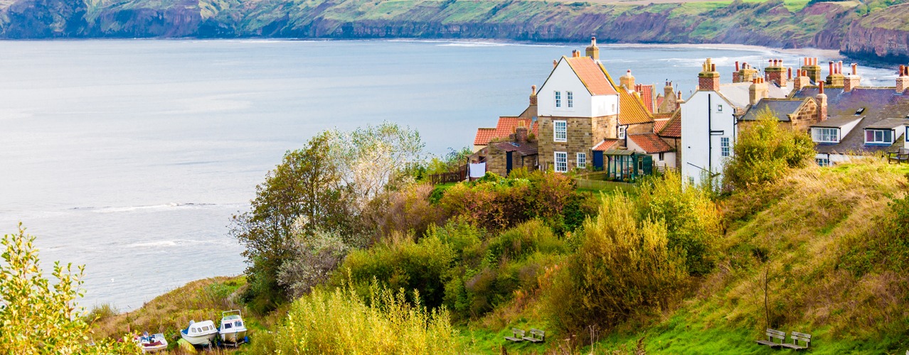
Littlebeck (50M) to Robin Hoods Bay. Distance 11 miles
The route follows a woodland trail. After the woodland the path rises and crosses a final stretch of heather moorland before following country lanes to the coast. This time the path turns south to follow a coastal path to Robin Hoods Bay and a final last descent to the sea. Please don't forget to follow tradition once more by dipping your boot in the sea and throwing your pebble in (that should baffle the geologists in years to come). Your challenge is complete. Robin Hoods Bay is a picturesque once fishing village and reputed smugglers haunt. Being built on the hillside the street from top to bottom of the village is the final steep descent/ascent on route.
Booking
Our self guided holidays are booked on an individual basis and therefore you can start your holiday on any date of your choice between April and early October.
This Holiday Includes
- 19 nights accommodation with breakfast
- Carefully selected walker-friendly accommodation
- Breakfast each day
- Luggage transfer between overnight accommodation
- Route information and itinerary
- Detailed instructions to find your accommodation
- Guidebook with downloadable GPS waypoints and a route map
- Emergency contact 24 hours a day
- Holiday price £2110 per person based
- Single supplement £760
-
Coast to Coast 18 Nights/17 Days Itinerary
- 18 Nights Accommodation
- 17 Days Walking
- Total distance 191 miles
Home › Articles by: Dean Halsall
18 Nights Accommodation/17 Days Walking
- Day 1 Travel to St Bees where your first nights accommodation is booked
- Day 2 St Bees to Ennerdale Bridge. 14 miles.
- Day 3 Ennerdale Bridge to Rosthwaite. 14 miles.
- Day 4 Rosthwaite to Grasmere. 10 miles.
- Day 5 Grasmere to Patterdale. 8 miles.
- Day 6 Patterdale to Shap. 16 miles.
- Day 7 Shap to Orton. 8 miles.
- Day 8 Orton to Kirkby Stephen. 12 miles.
- Day 9 Kirkby Stephen to Keld. 13 miles.
- Day 10 Keld to Reeth. 11 miles.
- Day 11 Reeth to Richmond. 11 miles.
- Day 12 Richmond to Danby Wiske. 13 miles.
- Day 13 Danby Wiske to Ingleby Cross. 11 miles.
- Day 14 Ingleby Cross to Clay Bank Top. 11 miles.
- Day 15 Clay Bank Top to Blakey Ridge. 9 miles.
- Day 16 Blakey Ridge to Glaisdale. 10 miles.
- Day 17 Glaisdale to Littlebeck. 8 miles.
- Day 18 Littlebeck to Robin Hoods Bay. 11 miles.
- Day 19 Depart Robin Hoods Bay for home
Route Description
St Bees to Ennerdale Bridge (above sea level 100M). Distance 14 miles
A plaque on the seafront marks the start of Wainwrights coast to coast walk. Tradition says to dip your toe in the sea and then collect a small pebble to carry with you to the east coast. The route heads north across the coastal path with views of Scotland and the Isle of Man. Leave the coastal path and head east towards the Lake District Mountains. The route passes through the villages of Sandwith and Moor Row to Cleator. From Cleator the route starts to climb and a steep walk takes you to Dent summit (352M). Admire the views before continuing across the hilltop. Descend steeply down a forest track, follow Nannycatch Beck and then the roadside paths to Ennerdale Bridge.
Ennerdale Bridge (100M) to Rosthwaite (100M). Distance 14 miles
Follow the country lanes to Ennerdale Water then the rocky path along the banks of the Lake. At the far end of the Lake make for the forest track that climbs gradually along Ennerdale valley to the remote Black Sail Hut YHA (290M). The adventurous and experienced fell walkers can leave the track and climb to follow the alternative route over High Stile (807M), rejoining the main route near the top of Loft Beck. From the YHA continue to the bottom of Loft Beck and a steep ascent to the high point of the day at 600M. The views back to the sea are spectacular. Follow the rocky path across the fell and descend to Honister (330M). Continue descending into the beautiful Borrowdale valley to the village of Seatoller (120M) then follow the footpaths to Rosthwaite.
Rosthwaite (100M) to Grasmere (75M). Distance 10 miles
Follow the track alongside Stonethwaite Beck then the rocky path climbing steadily alongside Greenup Gill. Climb the steps and rocks (a bit tricky but not technical) to the left side of Lining Crag (500M) and admire the views to the north and east. Continue to Greenup Edge, today’s high point at 620M, and then descend the rocky path to the head of Far Easedale. You then have the option to follow the ridge walk across Calf Crag, Gibson Knott and Helm Crag before descending steeply into Grasmere or take the less arduous route down Far Easedale.
Grasmere (75M) to Patterdale/Glenridding (150M). Distance 8 miles
Follow the road to Mill Bridge then take the rocky path which climbs steadily alongside Tongue Gill to Grisedale Tarn (550M). The adventurous and experienced fell walkers can leave the route and climb higher to follow one of the alternative routes, either right over St Sunday Crag (841M), or left onto Helvellyn (950M) and then across the infamous Striding Edge. From Grisedale Tarn follow the route down hill alongside Grisedale Beck into Patterdale.
Patterdale (150M) to Shap (250M). Distance 16 miles
From Patterdale a sharp steep walk brings you to Boredale Hause (400M), the rocky path now climbs with less gradient past Angle Tarn and close to Satura Crag (600M), it descends to 500M and then climbs sharply again to round The Knott (739M). The route then turns sharp left onto High Street, an old Roman Road, and then right onto Kidsty Pike (780M) the highest point on route. From here look back across the Lake District and then turn to view the Eden Valley and the Pennine Mountains. Descend gradually at first then steeply down to Haweswater (250M), and follow the rocky path alongside the banks of the reservoir to Burnbanks. The Lake District Mountains are left behind and the gradients ease to cross the rolling farmland in Eden Valley. Follow the paths across undulating farmland, passing the ruins of Shap Abbey, to the village of Shap.
Shap (250M) to Orton (230M). Distance 8 miles
Continue along footpaths across the limestone plateau passing the secluded hamlet of Oddendale and the granite boulders deposited by ice age glaciers on route to the village Orton.
Orton (230M) to Kirkby Stephen (180M). Distance 12 miles
Continue over rolling farmland and across the moorland passing Sunbiggin, the hidden remains of several ancient settlements, and Smardale Bridge to the market town Kirkby Stephen.
Kirkby Stephen (180M) to Keld (350M). Distance 13 miles
Cross Franks Bridge and head for the lane which becomes a broad path onto the Pennine Moors and the summit of Nine Standards Rigg (662M). Depending on the time of year there are three routes over and around Nine Standards; green (avoiding the summit) for winter and spring, red for early summer, and blue for late summer and autumn. All routes cross peat, which is notoriously boggy in wet weather, before descending to the River Swale and the road in to Keld.
Keld (350M) to Reeth (200M). Distance 11 miles
From Keld you have a choice of routes. The main route stays high and crosses moorland that is scarred from a lead mining industry that disappeared at the end of the 19th century. From Keld the route descends to the river then climbs past Crackpot Hall and the ruins of Swinner Gill mine workings. It crosses the moor (580M) before dropping into Gunnerside Gill (400M) and then up onto Melbecks Moor (550M). From here a broad track descends gradually passing the ruins of Old Gang Smelting Mills to Surrender Bridge (350M) and another smelt mill. The last test of the day is to drop into Cringley Bottom, cross the river and then continue over the farmland to Reeth. The alternative route, is to follow the ‘royal road’ through Swaledale valley. The route passes through Gunnerside and a few pleasant small Yorkshire Dales villages.
Reeth (200M) to Richmond (150M). Distance 11 miles
This is a much easier day’s walk across rolling countryside passing Marrick Priory, Marske village and Whitecliffe wood to the largest town on route, Richmond.
Richmond (150M) to Danby Wiske (36M). Distance 13 miles
The route to Danby Wiske is almost level and generally easy going, it crosses farmlands to Bolton on Swale and then follows 7 miles of country lanes across the low lying Vale of Mowbray.
Danby Wiske (36M) to Ingleby Cross (80M). Distance 9 miles
The path remains easy going initially following the country lanes before returning to farm land. Take care crossing the busy A19 road.
Ingleby Cross (80M) to Clay Bank Top (250M). Distance 13 miles
This is the start of the crossing over the Cleveland Hills and the North York Moors, which are covered in purple heather during late summer months. The route follows the Cleveland Way trail and climbs steadily over Beacon Hill (299M) then descends into Scugdale (100M). The path climbs steadily at first then steeply onto Gold Hill (315M). It continues onto Carlton Moor (408M) before descending to Green Bank (300M). Once again it climbs going over Cringle Moor (430M), descends to 280M back up to 400M, down again to 300M and then a final climb through the Wainstones onto Hasty Bank (398M) before descending to the road at Clay Bank Top (250M). If all the up and down seems like too much hard work there is a path that contours round the hills from Green Bank to Clay Bank.
Clay Bank Top (250M) to Blakey Ridge (400M). Distance 9 miles
There is a steep ascent to Carr Ridge (390M) followed by a gradual rise to the summit of Round Hill (454M), the highest point on the North York Moors. The path descends to Bloworth Crossing (400M) were it leaves the Cleveland Way and continues on an almost level disused railway line across the desolate moors to the remote Lion Inn on Blakey Ridge.
Blakey Ridge (400M) to Glaisdale (120M). Distance 10 miles
After a few miles alongside the road the route follows a track across the heather clad moors. There is another road walk and then the route continues along a broad disused track gradually descending Glaisdale Moor into Glaisdale village.
Glaisdale (120M) to Littlebeck (50M). Distance 8 miles
The route follows the River Esk passing through East Arnecliffe Wood to Egton Bridge where it follows a once toll road through the private estate of Egton Manor to Grosmont. The road (the 1 in 3) climbs steeply out of Grosmont to its high point on Sleights Moor (285M). There are wonderful views to Whitby and the sea. The path descends through heather covered moorland in to Littlebeck.
Littlebeck (50M) to Robin Hoods Bay. Distance 11 miles
The route follows a woodland trail. After the woodland the path rises and crosses a final stretch of heather moorland before following country lanes to the coast. This time the path turns south to follow a coastal path to Robin Hoods Bay and a final last descent to the sea. Please don't forget to follow tradition once more by dipping your boot in the sea and throwing your pebble in (that should baffle the geologists in years to come). Your challenge is complete. Robin Hoods Bay is a picturesque once fishing village and reputed smugglers haunt. Being built on the hillside the street from top to bottom of the village is the final steep descent/ascent on route.
Booking
Our self guided holidays are booked on an individual basis and therefore you can start your holiday on any date of your choice between April and early October.
This Holiday Includes
- Carefully selected walker-friendly accommodation
- Breakfast each day
- Luggage transfer between overnight accommodation
- Route information and itinerary
- Detailed instructions to find your accommodation
- Guidebook with downloadable GPS waypoints and a route map
- Emergency contact 24 hours a day
- Holiday price £2000 per person
- Single supplement £720
-
Coast to Coast 17 Nights/16 Days Itinerary
- 17 Nights Accommodation
- 16 Days Walking
- Total distance 191 miles
Home › Articles by: Dean Halsall
17 Nights Accommodation/16 Days Walking
- Day 1 Travel to St Bees where your first nights accommodation is booked
- Day 2 St Bees to Ennerdale Bridge. 14 miles.
- Day 3 Ennerdale Bridge to Rosthwaite. 14 miles.
- Day 4 Rosthwaite to Grasmere. 10 miles.
- Day 5 Grasmere to Patterdale. 8 miles.
- Day 6 Patterdale to Shap. 16 miles.
- Day 7 Shap to Orton. 8 miles.
- Day 8 Orton to Kirkby Stephen. 12 miles.
- Day 9 Kirkby Stephen to Keld. 13 miles.
- Day 10 Keld to Reeth. 11 miles.
- Day 11 Reeth to Richmond. 11 miles.
- Day 12 Richmond to Danby Wiske. 13 miles.
- Day 13 Danby Wiske to Ingleby Cross. 11 miles.
- Day 14 Ingleby Cross to Clay Bank Top. 11 miles.
- Day 15 Clay Bank Top to Blakey Ridge. 9 miles.
- Day 16 Blakey Ridge to Grosmont. 15 miles.
- Day 17 Grosmont to Robin Hoods Bay. 15 miles.
- Day 18 Depart Robin Hoods Bay for home
Route Description
St Bees to Ennerdale Bridge (above sea level 100M). Distance 14 miles
A plaque on the seafront marks the start of Wainwrights coast to coast walk. Tradition says to dip your toe in the sea and then collect a small pebble to carry with you to the east coast. The route heads north across the coastal path with views of Scotland and the Isle of Man. Leave the coastal path and head east towards the Lake District Mountains. The route passes through the villages of Sandwith and Moor Row to Cleator. From Cleator the route starts to climb and a steep walk takes you to Dent summit (352M). Admire the views before continuing across the hilltop. Descend steeply down a forest track, follow Nannycatch Beck and then the roadside paths to Ennerdale Bridge.
Ennerdale Bridge (100M) to Rosthwaite (100M). Distance 14 miles
Follow the country lanes to Ennerdale Water then the rocky path along the banks of the Lake. At the far end of the Lake make for the forest track that climbs gradually along Ennerdale valley to the remote Black Sail Hut YHA (290M). The adventurous and experienced fell walkers can leave the track and climb to follow the alternative route over High Stile (807M), rejoining the main route near the top of Loft Beck. From the YHA continue to the bottom of Loft Beck and a steep ascent to the high point of the day at 600M. The views back to the sea are spectacular. Follow the rocky path across the fell and descend to Honister (330M). Continue descending into the beautiful Borrowdale valley to the village of Seatoller (120M) then follow the footpaths to Rosthwaite.
Rosthwaite (100M) to Grasmere (75M). Distance 10 miles
Follow the track alongside Stonethwaite Beck then the rocky path climbing steadily alongside Greenup Gill. Climb the steps and rocks (a bit tricky but not technical) to the left side of Lining Crag (500M) and admire the views to the north and east. Continue to Greenup Edge, today’s high point at 620M, and then descend the rocky path to the head of Far Easedale. You then have the option to follow the ridge walk across Calf Crag, Gibson Knott and Helm Crag before descending steeply into Grasmere or take the less arduous route down Far Easedale.
Grasmere (75M) to Patterdale/Glenridding (150M). Distance 8 miles
Follow the road to Mill Bridge then take the rocky path which climbs steadily alongside Tongue Gill to Grisedale Tarn (550M). The adventurous and experienced fell walkers can leave the route and climb higher to follow one of the alternative routes, either right over St Sunday Crag (841M), or left onto Helvellyn (950M) and then across the infamous Striding Edge. From Grisedale Tarn follow the route down hill alongside Grisedale Beck into Patterdale.
Patterdale (150M) to Shap (250M). Distance 16 miles
From Patterdale a sharp steep walk brings you to Boredale Hause (400M), the rocky path now climbs with less gradient past Angle Tarn and close to Satura Crag (600M), it descends to 500M and then climbs sharply again to round The Knott (739M). The route then turns sharp left onto High Street, an old Roman Road, and then right onto Kidsty Pike (780M) the highest point on route. From here look back across the Lake District and then turn to view the Eden Valley and the Pennine Mountains. Descend gradually at first then steeply down to Haweswater (250M), and follow the rocky path alongside the banks of the reservoir to Burnbanks. The Lake District Mountains are left behind and the gradients ease to cross the rolling farmland in Eden Valley. Follow the paths across undulating farmland, passing the ruins of Shap Abbey, to the village of Shap.
Shap (250M) to Orton (230M). Distance 8 miles
Continue along footpaths across the limestone plateau passing the secluded hamlet of Oddendale and the granite boulders deposited by ice age glaciers on route to the village Orton.
Orton (230M) to Kirkby Stephen (180M). Distance 12 miles
Continue over rolling farmland and across the moorland passing Sunbiggin, the hidden remains of several ancient settlements, and Smardale Bridge to the market town Kirkby Stephen.
Kirkby Stephen (180M) to Keld (350M). Distance 13 miles
Cross Franks Bridge and head for the lane which becomes a broad path onto the Pennine Moors and the summit of Nine Standards Rigg (662M). Depending on the time of year there are three routes over and around Nine Standards; green (avoiding the summit) for winter and spring, red for early summer, and blue for late summer and autumn. All routes cross peat, which is notoriously boggy in wet weather, before descending to the River Swale and the road in to Keld.
Keld (350M) to Reeth (200M). Distance 11 miles
From Keld you have a choice of routes. The main route stays high and crosses moorland that is scarred from a lead mining industry that disappeared at the end of the 19th century. From Keld the route descends to the river then climbs past Crackpot Hall and the ruins of Swinner Gill mine workings. It crosses the moor (580M) before dropping into Gunnerside Gill (400M) and then up onto Melbecks Moor (550M). From here a broad track descends gradually passing the ruins of Old Gang Smelting Mills to Surrender Bridge (350M) and another smelt mill. The last test of the day is to drop into Cringley Bottom, cross the river and then continue over the farmland to Reeth. The alternative route, is to follow the ‘royal road’ through Swaledale valley. The route passes through Gunnerside and a few pleasant small Yorkshire Dales villages.
Reeth (200M) to Richmond (150M). Distance 11 miles
This is a much easier day’s walk across rolling countryside passing Marrick Priory, Marske village and Whitecliffe wood to the largest town on route, Richmond.
Richmond (150M) to Danby Wiske (36M). Distance 13 miles
The route to Danby Wiske is almost level and generally easy going, it crosses farmlands to Bolton on Swale and then follows 7 miles of country lanes across the low lying Vale of Mowbray.
Danby Wiske (36M) to Ingleby Cross (80M). Distance 9 miles
The path remains easy going initially following the country lanes before returning to farm land. Take care crossing the busy A19 road.
Ingleby Cross (80M) to Clay Bank Top (250M). Distance 13 miles
This is the start of the crossing over the Cleveland Hills and the North York Moors, which are covered in purple heather during late summer months. The route follows the Cleveland Way trail and climbs steadily over Beacon Hill (299M) then descends into Scugdale (100M). The path climbs steadily at first then steeply onto Gold Hill (315M). It continues onto Carlton Moor (408M) before descending to Green Bank (300M). Once again it climbs going over Cringle Moor (430M), descends to 280M back up to 400M, down again to 300M and then a final climb through the Wainstones onto Hasty Bank (398M) before descending to the road at Clay Bank Top (250M). If all the up and down seems like too much hard work there is a path that contours round the hills from Green Bank to Clay Bank.
Clay Bank Top (250M) to Blakey Ridge (400M). Distance 9 miles
There is a steep ascent to Carr Ridge (390M) followed by a gradual rise to the summit of Round Hill (454M), the highest point on the North York Moors. The path descends to Bloworth Crossing (400M) were it leaves the Cleveland Way and continues on an almost level disused railway line across the desolate moors to the remote Lion Inn on Blakey Ridge.
Blakey Ridge (400M) to Grosmont (50M). Distance 15 miles
The route follows an old toll road through the private estate of Egton Manor to Grosmont.
Grosmont (50M) to Robin Hoods Bay. Distance 17 miles
The road (the 1 in 3) climbs steeply out of Grosmont to its high point on Sleights Moor (285M). There are wonderful views to Whitby and the sea. The path descends through heather covered moorland in to Littlebeck. The route follows a woodland trail. After the woodland the path rises and crosses a final stretch of heather moorland before following country lanes to the coast. This time the path turns south to follow a coastal path to Robin Hoods Bay and a final last descent to the sea. Please don't forget to follow tradition once more by dipping your boot in the sea and throwing your pebble in (that should baffle the geologists in years to come). Your challenge is complete. Robin Hoods Bay is a picturesque once fishing village and reputed smugglers haunt. Being built on the hillside the street from top to bottom of the village is the final steep descent/ascent on route.
Booking
Our self guided holidays are booked on an individual basis and therefore you can start your holiday on any date of your choice between April and early October.
This Holiday Includes
- Carefully selected walker-friendly accommodation
Breakfast each day
Luggage transfer between overnight accommodation
Route information and itinerary
Detailed instructions to find your accommodation
Guidebook with downloadable GPS waypoints and a route map
Emergency contact 24 hours a day
Holiday price £1890 per person
Single supplement £680
-
Coast to Coast 16 Nights/15 Days Itinerary
- 16 Nights Accommodation
- 15 Days Walking
- Total distance 191 miles
Home › Articles by: Dean Halsall
16 Nights Accommodation/15 Days Walking
- Day 1 Travel to St Bees where your first nights accommodation is booked
- Day 2 St Bees to Ennerdale Bridge. 14 miles.
- Day 3 Ennerdale Bridge to Rosthwaite. 14 miles.
- Day 4 Rosthwaite to Grasmere. 10 miles.
- Day 5 Grasmere to Patterdale. 8 miles.
- Day 6 Patterdale to Shap. 16 miles.
- Day 7 Shap to Orton. 8 miles.
- Day 8 Orton to Kirkby Stephen. 12 miles.
- Day 9 Kirkby Stephen to Keld. 13 miles.
- Day 10 Keld to Reeth. 11 miles.
- Day 11 Reeth to Richmond. 11 miles.
- Day 12 Richmond to Danby Wiske. 13 miles.
- Day 13 Danby Wiske to Ingleby Cross. 11 miles.
- Day 14 Ingleby Cross to Clay Bank Top. 11 miles.
- Day 15 Clay Bank Top to Glaisdale. 19 miles.
- Day 16 Glaisdale to Robin Hoods Bay. 19 miles.
- Day 17 Depart Robin Hoods Bay for home
Route Description
St Bees to Ennerdale Bridge (above sea level 100M). Distance 14 miles
A plaque on the seafront marks the start of Wainwrights coast to coast walk. Tradition says to dip your toe in the sea and then collect a small pebble to carry with you to the east coast. The route heads north across the coastal path with views of Scotland and the Isle of Man. Leave the coastal path and head east towards the Lake District Mountains. The route passes through the villages of Sandwith and Moor Row to Cleator. From Cleator the route starts to climb and a steep walk takes you to Dent summit (352M). Admire the views before continuing across the hilltop. Descend steeply down a forest track, follow Nannycatch Beck and then the roadside paths to Ennerdale Bridge.
Ennerdale Bridge (100M) to Rosthwaite (100M). Distance 14 miles
Follow the country lanes to Ennerdale Water then the rocky path along the banks of the Lake. At the far end of the Lake make for the forest track that climbs gradually along Ennerdale valley to the remote Black Sail Hut YHA (290M). The adventurous and experienced fell walkers can leave the track and climb to follow the alternative route over High Stile (807M), rejoining the main route near the top of Loft Beck. From the YHA continue to the bottom of Loft Beck and a steep ascent to the high point of the day at 600M. The views back to the sea are spectacular. Follow the rocky path across the fell and descend to Honister (330M). Continue descending into the beautiful Borrowdale valley to the village of Seatoller (120M) then follow the footpaths to Rosthwaite.
Rosthwaite (100M) to Grasmere (75M). Distance 10 miles
Follow the track alongside Stonethwaite Beck then the rocky path climbing steadily alongside Greenup Gill. Climb the steps and rocks (a bit tricky but not technical) to the left side of Lining Crag (500M) and admire the views to the north and east. Continue to Greenup Edge, today’s high point at 620M, and then descend the rocky path to the head of Far Easedale. You then have the option to follow the ridge walk across Calf Crag, Gibson Knott and Helm Crag before descending steeply into Grasmere or take the less arduous route down Far Easedale.
Grasmere (75M) to Patterdale/Glenridding (150M). Distance 8 miles
Follow the road to Mill Bridge then take the rocky path which climbs steadily alongside Tongue Gill to Grisedale Tarn (550M). The adventurous and experienced fell walkers can leave the route and climb higher to follow one of the alternative routes, either right over St Sunday Crag (841M), or left onto Helvellyn (950M) and then across the infamous Striding Edge. From Grisedale Tarn follow the route down hill alongside Grisedale Beck into Patterdale.
Patterdale (150M) to Shap (250M). Distance 16 miles
From Patterdale a sharp steep walk brings you to Boredale Hause (400M), the rocky path now climbs with less gradient past Angle Tarn and close to Satura Crag (600M), it descends to 500M and then climbs sharply again to round The Knott (739M). The route then turns sharp left onto High Street, an old Roman Road, and then right onto Kidsty Pike (780M) the highest point on route. From here look back across the Lake District and then turn to view the Eden Valley and the Pennine Mountains. Descend gradually at first then steeply down to Haweswater (250M), and follow the rocky path alongside the banks of the reservoir to Burnbanks. The Lake District Mountains are left behind and the gradients ease to cross the rolling farmland in Eden Valley. Follow the paths across undulating farmland, passing the ruins of Shap Abbey, to the village of Shap.
Shap (250M) to Orton (230M). Distance 8 miles
Continue along footpaths across the limestone plateau passing the secluded hamlet of Oddendale and the granite boulders deposited by ice age glaciers on route to the village Orton.
Orton (230M) to Kirkby Stephen (180M). Distance 12 miles
Continue over rolling farmland and across the moorland passing Sunbiggin, the hidden remains of several ancient settlements, and Smardale Bridge to the market town Kirkby Stephen.
Kirkby Stephen (180M) to Keld (350M). Distance 13 miles
Cross Franks Bridge and head for the lane which becomes a broad path onto the Pennine Moors and the summit of Nine Standards Rigg (662M). Depending on the time of year there are three routes over and around Nine Standards; green (avoiding the summit) for winter and spring, red for early summer, and blue for late summer and autumn. All routes cross peat, which is notoriously boggy in wet weather, before descending to the River Swale and the road in to Keld.
Keld (350M) to Reeth (200M). Distance 11 miles
From Keld you have a choice of routes. The main route stays high and crosses moorland that is scarred from a lead mining industry that disappeared at the end of the 19th century. From Keld the route descends to the river then climbs past Crackpot Hall and the ruins of Swinner Gill mine workings. It crosses the moor (580M) before dropping into Gunnerside Gill (400M) and then up onto Melbecks Moor (550M). From here a broad track descends gradually passing the ruins of Old Gang Smelting Mills to Surrender Bridge (350M) and another smelt mill. The last test of the day is to drop into Cringley Bottom, cross the river and then continue over the farmland to Reeth. The alternative route, is to follow the ‘royal road’ through Swaledale valley. The route passes through Gunnerside and a few pleasant small Yorkshire Dales villages.
Reeth (200M) to Richmond (150M). Distance 11 miles
This is a much easier day’s walk across rolling countryside passing Marrick Priory, Marske village and Whitecliffe wood to the largest town on route, Richmond.
Richmond (150M) to Danby Wiske (36M). Distance 13 miles
The route to Danby Wiske is almost level and generally easy going, it crosses farmlands to Bolton on Swale and then follows 7 miles of country lanes across the low lying Vale of Mowbray.
Danby Wiske (36M) to Ingleby Cross (80M). Distance 9 miles
The path remains easy going initially following the country lanes before returning to farm land. Take care crossing the busy A19 road.
Ingleby Cross (80M) to Clay Bank Top (250M). Distance 13 miles
This is the start of the crossing over the Cleveland Hills and the North York Moors, which are covered in purple heather during late summer months. The route follows the Cleveland Way trail and climbs steadily over Beacon Hill (299M) then descends into Scugdale (100M). The path climbs steadily at first then steeply onto Gold Hill (315M). It continues onto Carlton Moor (408M) before descending to Green Bank (300M). Once again it climbs going over Cringle Moor (430M), descends to 280M back up to 400M, down again to 300M and then a final climb through the Wainstones onto Hasty Bank (398M) before descending to the road at Clay Bank Top (250M). If all the up and down seems like too much hard work there is a path that contours round the hills from Green Bank to Clay Bank.
Clay Bank Top (250M) to Glaisdale (120M). Distance 19 miles
There is a steep ascent to Carr Ridge (390M) followed by a gradual rise to the summit of Round Hill (454M), the highest point on the North York Moors. The path descends to Bloworth Crossing (400M) were it leaves the Cleveland Way and continues on an almost level disused railway line across the desolate moors to the remote Lion Inn on Blakey Ridge. After a few miles alongside the road the route follows a track across the heather clad moors. There is another road walk and then the route continues along a broad disused track gradually descending Glaisdale Moor into Glaisdale village.
Glaisdale (120M) to Robin Hoods Bay. Distance 19 miles
The route follows the River Esk passing through East Arnecliffe Wood to Egton Bridge where it follows a once toll road through the private estate of Egton Manor to Grosmont.The road (the 1 in 3) climbs steeply out of Grosmont to its high point on Sleights Moor (285M). There are wonderful views to Whitby and the sea. The path descends through heather covered moorland in to Littlebeck. The route follows a woodland trail. After the woodland the path rises and crosses a final stretch of heather moorland before following country lanes to the coast. This time the path turns south to follow a coastal path to Robin Hoods Bay and a final last descent to the sea. Please don't forget to follow tradition once more by dipping your boot in the sea and throwing your pebble in (that should baffle the geologists in years to come). Your challenge is complete. Robin Hoods Bay is a picturesque once fishing village and reputed smugglers haunt. Being built on the hillside the street from top to bottom of the village is the final steep descent/ascent on route.
Booking
Our self guided holidays are booked on an individual basis and therefore you can start your holiday on any date of your choice between April and early October.
This Holiday Includes
- Carefully selected walker-friendly accommodation
- Breakfast each day
- Luggage transfer between overnight accommodation
- Route information and itinerary
- Detailed instructions to find your accommodation
- Guidebook with downloadable GPS waypoints and a route map
- Emergency contact 24 hours a day
- Holiday price £1790 per person based on two people sharing a room
- Single supplement £640
-
Coast to Coast 15 Nights/14 Days Itinerary
- 15 Nights Accommodation
- 14 Days Walking
- Total distance 191 miles
Home › Articles by: Dean Halsall
15 Nights Accommodation/14 Days Walking
- Day 1 Travel to St Bees where your first nights accommodation is booked.
- Day 2 St Bees to Ennerdale Bridge. 14 miles.
- Day 3 Ennerdale Bridge to Rosthwaite. 14 miles.
- Day 4 Rosthwaite to Grasmere. 10 miles.
- Day 5 Grasmere to Patterdale. 8 miles.
- Day 6 Patterdale to Shap. 16 miles.
- Day 7 Shap to Kirkby Stephen. 21 miles.
- Day 8 Kirkby Stephen to Keld. 13 miles.
- Day 9 Keld to Reeth. 11 miles.
- Day 10 Reeth to Richmond. 11 miles.
- Day 11 Richmond to Ingleby Cross. 22 miles.
- Day 12 Ingleby Cross to Clay Bank Top. 13 miles.
- Day 13 Clay Bank Top to Blakey Ridge. 9 miles.
- Day 14 Blakey Ridge to Grosmont. 15 miles.
- Day 15 Grosmont to Robin Hoods Bay. 15 miles.
- Day 16 Depart Robin Hoods Bay for home.
Route Description
St Bees to Ennerdale Bridge (above sea level 100M). Distance 14 miles
A plaque on the seafront marks the start of Wainwrights coast to coast walk. Tradition says to dip your toe in the sea and then collect a small pebble to carry with you to the east coast. The route heads north across the coastal path with views of Scotland and the Isle of Man. Leave the coastal path and head east towards the Lake District Mountains. The route passes through the villages of Sandwith and Moor Row to Cleator. From Cleator the route starts to climb and a steep walk takes you to Dent summit (352M). Admire the views before continuing across the hilltop. Descend steeply down a forest track, follow Nannycatch Beck and then the roadside paths to Ennerdale Bridge.
Ennerdale Bridge (100M) to Rosthwaite (100M). Distance 14 miles
Follow the country lanes to Ennerdale Water then the rocky path along the banks of the Lake. At the far end of the Lake make for the forest track that climbs gradually along Ennerdale valley to the remote Black Sail Hut YHA (290M). The adventurous and experienced fell walkers can leave the track and climb to follow the alternative route over High Stile (807M), rejoining the main route near the top of Loft Beck. From the YHA continue to the bottom of Loft Beck and a steep ascent to the high point of the day at 600M. The views back to the sea are spectacular. Follow the rocky path across the fell and descend to Honister (330M). Continue descending into the beautiful Borrowdale valley to the village of Seatoller (120M) then follow the footpaths to Rosthwaite.
Rosthwaite (100M) to Grasmere (75M). Distance 10 miles
Follow the track alongside Stonethwaite Beck then the rocky path climbing steadily alongside Greenup Gill. Climb the steps and rocks (a bit tricky but not technical) to the left side of Lining Crag (500M) and admire the views to the north and east. Continue to Greenup Edge, today’s high point at 620M, and then descend the rocky path to the head of Far Easedale. You then have the option to follow the ridge walk across Calf Crag, Gibson Knott and Helm Crag before descending steeply into Grasmere or take the less arduous route down Far Easedale.
Grasmere (75M) to Patterdale/Glenridding (150M). Distance 8 miles
Follow the road to Mill Bridge then take the rocky path which climbs steadily alongside Tongue Gill to Grisedale Tarn (550M). The adventurous and experienced fell walkers can leave the route and climb higher to follow one of the alternative routes, either right over St Sunday Crag (841M), or left onto Helvellyn (950M) and then across the infamous Striding Edge. From Grisedale Tarn follow the route down hill alongside Grisedale Beck into Patterdale.
Patterdale (150M) to Shap (250M). Distance 16 miles
From Patterdale a sharp steep walk brings you to Boredale Hause (400M), the rocky path now climbs with less gradient past Angle Tarn and close to Satura Crag (600M), it descends to 500M and then climbs sharply again to round The Knott (739M). The route then turns sharp left onto High Street, an old Roman Road, and then right onto Kidsty Pike (780M) the highest point on route. From here look back across the Lake District and then turn to view the Eden Valley and the Pennine Mountains. Descend gradually at first then steeply down to Haweswater (250M), and follow the rocky path alongside the banks of the reservoir to Burnbanks. The Lake District Mountains are left behind and the gradients ease to cross the rolling farmland in Eden Valley. Follow the paths across undulating farmland, passing the ruins of Shap Abbey, to the village of Shap.
Shap (250M) to Kirkby Stephen (180M). Distance 21 miles
Follow the footpaths across the limestone plateau passing the secluded hamlet of Oddendale and the granite boulders deposited by ice age glaciers. The route continues over rolling farmland and across the moorland passing Sunbiggin, the hidden remains of several ancient settlements, and Smardale Bridge to the market town Kirkby Stephen.
Kirkby Stephen (180M) to Keld (350M). Distance 13 miles
Cross Franks Bridge and head for the lane which becomes a broad path onto the Pennine Moors and the summit of Nine Standards Rigg (662M). Depending on the time of year there are three routes over and around Nine Standards; green (avoiding the summit) for winter and spring, red for early summer, and blue for late summer and autumn. All routes cross peat, which is notoriously boggy in wet weather, before descending to the River Swale and the road in to Keld.
Keld (350M) to Reeth (200M). Distance 11 miles
From Keld you have a choice of routes. The main route stays high and crosses moorland that is scarred from a lead mining industry that disappeared at the end of the 19th century. From Keld the route descends to the river then climbs past Crackpot Hall and the ruins of Swinner Gill mine workings. It crosses the moor (580M) before dropping into Gunnerside Gill (400M) and then up onto Melbecks Moor (550M). From here a broad track descends gradually passing the ruins of Old Gang Smelting Mills to Surrender Bridge (350M) and another smelt mill. The last test of the day is to drop into Cringley Bottom, cross the river and then continue over the farmland to Reeth. The alternative route, is to follow the ‘royal road’ through Swaledale valley. The route passes through Gunnerside and a few pleasant small Yorkshire Dales villages.
Reeth (200M) to Richmond (150M). Distance 11 miles
This is a much easier day’s walk across rolling countryside passing Marrick Priory, Marske village and Whitecliffe wood to the largest town on route, Richmond.
Richmond (150M) to Ingleby Cross (80M). Distance 22 miles
The route to Ingleby Cross is almost level and generally easy going, it crosses farmlands to Bolton on Swale and then follows 7 miles of country lanes across the low lying Vale of Mowbray to Danby Wiske. The path remains easy going initially following the country lanes before returning to farm land. Take care crossing the busy A19 road.
Ingleby Cross (80M) to Clay Bank Top (250M). Distance 13 miles
This is the start of the crossing over the Cleveland Hills and the North York Moors, which are covered in purple heather during late summer months. The route follows the Cleveland Way trail and climbs steadily over Beacon Hill (299M) then descends into Scugdale (100M). The path climbs steadily at first then steeply onto Gold Hill (315M). It continues onto Carlton Moor (408M) before descending to Green Bank (300M). Once again it climbs going over Cringle Moor (430M), descends to 280M back up to 400M, down again to 300M and then a final climb through the Wainstones onto Hasty Bank (398M) before descending to the road at Clay Bank Top (250M). If all the up and down seems like too much hard work there is a path that contours round the hills from Green Bank to Clay Bank.
Clay Bank Top (250M) to Blakey Ridge (400M). Distance 9 miles
There is a steep ascent to Carr Ridge (390M) followed by a gradual rise to the summit of Round Hill (454M), the highest point on the North York Moors. The path descends to Bloworth Crossing (400M) were it leaves the Cleveland Way and continues on an almost level disused railway line across the desolate moors to the remote Lion Inn on Blakey Ridge.
Blakey Ridge (400M) to Grosmont (50M). Distance 15 miles
The route follows an old toll road through the private estate of Egton Manor to Grosmont.
Grosmont (50M) to Robin Hoods Bay. Distance 15 miles
The road (the 1 in 3) climbs steeply out of Grosmont to its high point on Sleights Moor (285M). There are wonderful views to Whitby and the sea. The path descends through heather covered moorland in to Littlebeck. The route follows a woodland trail. After the woodland the path rises and crosses a final stretch of heather moorland before following country lanes to the coast. This time the path turns south to follow a coastal path to Robin Hoods Bay and a final last descent to the sea. Please don't forget to follow tradition once more by dipping your boot in the sea and throwing your pebble in (that should baffle the geologists in years to come). Your challenge is complete. Robin Hoods Bay is a picturesque once fishing village and reputed smugglers haunt. Being built on the hillside the street from top to bottom of the village is the final steep descent/ascent on route.
Booking
Our self guided holidays are booked on an individual basis and therefore you can start your holiday on any date of your choice between April and early October.
This Holiday Includes
- Carefully selected walker-friendly accommodation
- Breakfast each day
- Luggage transfer between overnight accommodation
- Route information and itinerary
- Detailed instructions to find your accommodation
- Guidebook with downloadable GPS waypoints and a route map
- Emergency contact 24 hours a day
- Holiday price £1685 per person based on two people sharing a room
- Single supplement £600