
Coast to Coast East Overview
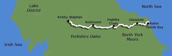
The Coast to Coast East is a 110 mile route across North Yorkshire. This is the Eastern section of Alfred Wainwright's famous coast to coast Walk from Kirkby Stephen to Robin Hoods Bay. You walk from west to east through stunning scenery, crossing the Yorkshire Dales and North York Moors National Parks. We operate itineraries from 7 to 10 days walking, so you can book an itinerary to meet your daily distance requirements and add rest days if required.
Holiday Includes
Tour Availability
This walking holiday is available from April to October. You can book your holiday to start on any date of your choice.
Accommodation
Accommodation is provided in carefully selected walker friendly B&Bs, Guest Houses, small Hotels and Inns along the route. All rooms are ensuite or have private bathroom. We provide detailed instructions to find you accommodation.
Meals
Breakfast is included. Packed lunches can be readily purchased from your overnight accommodation or local shop.
Evening meals can be purchased in local village pubs or overnight accommodation when a pub is not available.
Luggage transfer
For the duration of the holiday your luggage is transferred from accommodation to accommodation by a luggage transfer agent. Luggage allowance is 1 bag/person weighing not more than 20kg (44lbs).
Not Included
Evening meals, packed lunches, drinks and snacks, travel insurance, travel to Kirkby Stephen and from Robin Hoods Bay.
More Information?
For more information or to make an enquiry, please don't hesitate to call or email us.
