9 Nights Accommodation/8 Days Walking
- Day 1 Travel to Bowness-on-Solway where your first nights accommodation is booked
- Day 2 Bowness-on-Solway to Carlisle - 15 miles
- Day 3 Carlisle to Newtown - 8 miles
- Day 4 Newtown to Gilsland - 11 miles
- Day 5 Gilsland to Steel Rigg - 8 miles
- Day 6 Steel Rigg to Chollerford - 12 miles
- Day 7 Chollerford to East Wallhouses - 9 miles
- Day 8 East Wallhouses to Newburn - 10 miles
- Day 9 Newburn to Wallsend - 11 miles
Route Description
Bowness-on-Solway (height above sea level 5m) to Carlisle (15m). Distance 15 miles.
Walking West to East, a small shelter and pretty garden in the village of Bowness-on-Solway mark the start of Hadrian’s Wall Path. Not since the end of the Roman occupation of Britain, some 1600 years ago, has it been possible to walk along the entire length of Hadrian's Wall. The route to Carlisle is almost level. The first 7 or 8 miles follow a roadside path alongside the peaceful Solway Estuary. There are wonderful views across the estuary to the hills in Southern Scotland. The path passes through the village of Burgh by Sands (20m) and shortly after follows the River Eden to Carlisle. The border City of Carlisle is close to the Scottish border. The Romans established a settlement here to serve the forts on Hadrian’s Wall. Carlisle Castle is a great medieval fortress which houses the Border Regiment Museum. Carlisle is also at the end of the 70 mile Cumbria Way long distance walking route which crosses the Lake District from Ulverston at the southern end.
Carlisle (15m) to Newtown (70m). Distance 8 miles.
From Carlisle the path alternates from riverside to roadside walking as it makes its way to Crosby-on-Eden (30m). The route leaves the river and you continue across almost level farmland to the village of Newtown (70m). There are no ruins of the wall or forts to be seen on this section of the walk, but the occasional humps and bumps in the ground and glimpse of vallum ditch show the line of the Wall.
Newtown (70m) to Gilsland (130m). Distance 11 miles.
Shortly after leaving Newtown, you pass through the village of Walton (80m) and in a few miles the hamlet of Banks (120m). After Banks there is evidence of Hadrian’s Wall as the path continues across farmland to Birdoswald Fort (open daily from April to September), which is a mile before Gilsland (130m).
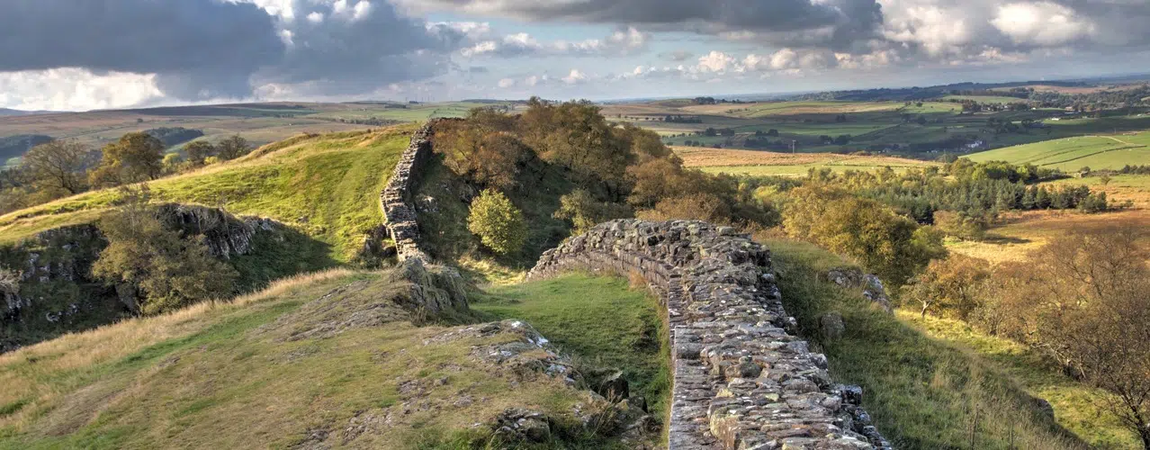
Gilsland (130m) to Steel Rigg (280m). Distance 8 miles.
You leave Cumbria and pass into Northumberland. At Greenhead you meet the 268 mile Pennine long distance National Trail, an upland walking route which leads from Edale in Derbyshire to Kirk Yetholm in the Scottish Borders. The landscape changes and at Walltown Crags there are views of southern Scotland and the Northern Pennines, and back to the Solway Firth. Hadrian’s Wall Path climbs onto the Crags and for the next few miles continues its route over the Crags alongside good sections of the Wall. The Wall was built on a line of rocky Crags which created a high defence to potential invaders from the north. There are excellent views of the surrounding area and Northumberland National Park. The path reaches its highest point at Windshields Crags (345m), there isn't very much between yourself and the Shetlands, a wasteland occupied by ‘The Barbarians’, or so the Romans called them, two millennia ago. From Steel Rigg you are approximately 2 miles from Vindolanda Fort, which is open daily from April to September.
Steel Rigg (280m) to Chollerford (100m). Distance 12 miles.
On this stage there are the most complete sections of the Wall, forts, milecastles, turret sections and wonderful views as the Wall crosses the Pennine Hills. For the next several miles the path rises and falls as it crosses the Crags, passing Housesteads Fort (275m). Near milecastle 34 (250m) Hadrian’s Wall leaves the crags and meets the B6318 road, which is dubbed the military road, not on account of the Romans, rather General Wade, builder of military supply roads in the 18th century in response to the Jacobite rebellion. It follows the line of the military road for several miles, descending towards Chollerford (100m). On route the path passes Limestone Corner, the most northerly point of the Wall. At Chollerford there are the ruins of Chesters Roman Fort and Chesters Museum, open daily from April to September.
Chollerford (100m) to East Wallhouses (140m). Distance 9 miles.
Shortly after leaving Chollerford the path passes St. Oswald’s Church at Heavenfield (220m), the site of a 7th century battle between Northumbrian forces and an invading Welsh army. The battle was a decisive victory for Oswald, King of Northumbria. The 97 mile St. Oswald’s Way long distance walking route leads from Heavenfield to Holy Island, and Hadrian’s Wall path and St Oswald’s Way follow the same path for the next few miles. The route continues in an almost straight line alongside the military road. At the junction with the A68 road is Portgate (200m), which was the junction with the Wall and Dere Street, the main Roman road into Scotland. The historical market town of Corbridge is a few miles to the south of the path. The route continues to the hamlet of East Wallhouses (140m).
East Wallhouses (140m) to Newburn (5m). Distance 10 miles.
The route is almost straight and level as it follows the line of the military road, where the Wall once stood, to Heddon-on-the-Wall. On the north side of the road you will see the ditch in places and the occasional ridge in the fields to the south. At Heddon-on-the-Wall is the last section of the Wall. The route now leads towards the River Tyne. At the river Hadrian’s Wall path turns left towards Newburn and Newcastle, but if you turn right along the Waggonway for a short distance it brings you to Wylam birthplace of George Stephenson.
Newburn (5m) to Wallsend (5m). Distance 11 miles.
Hadrian’s Wall Path continues alongside the River Tyne to Newcastle. The route leads through Newcastle Quayside, a vibrant area with restaurants and cafes. The bridges, including the tilting Millennium Bridge ('Winking Eye Bridge') link Newcastle to Gateshead. After leaving the city centre the route follows alongside the River Tyne, passing the shipyards and Newcastle’s industrial centre for the last several miles to Wallsend. The end of Hadrian’s Wall Path is at the remains of Segedunum Roman Fort (open Monday to Saturday 10am to 3pm).
Booking
Our self guided holidays are booked on an individual basis and therefore you can start your holiday on any date of your choice between April and early October.